Approximate Location Map
Large Map »
Latitude: 51.2705 / 51°16'13"N
Longitude: 0.5251 / 0°31'30"E
OS Eastings: 576244
OS Northings: 155399
OS Grid: TQ762553
Mapcode National: GBR PR7.7L1
Mapcode Global: VHJMF.1BZD
Plus Code: 9F327GCG+53
Entry Name: 70, LOWER STONE STREET (See details for further address information)
Listing Date: 30 July 1951
Grade: II*
Source: Historic England
Source ID: 1336227
English Heritage Legacy ID: 173410
Also known as: Mile Farm House
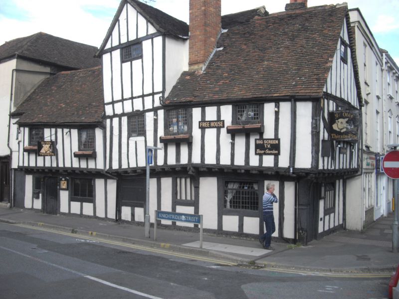
70 Lower Stone Street including 4A Knightrider Street
Ye Olde Thirsty Pig
ID on this website: 101336227
Location: Maidstone, Kent, ME15
County: Kent
District: Maidstone
Electoral Ward/Division: High Street
Parish: Non Civil Parish
Built-Up Area: Maidstone
Traditional County: Kent
Lieutenancy Area (Ceremonial County): Kent
Tagged with: Building
LOWER STONE STREET
5278
(West Side)
No 70
TQ 7655 SW 7/47 30.7.51.
II* GV
2.
Includes No 4A Knightrider Street. Together they are called Mile Farm House.
Interesting restored C15 timber framed building with the 1st floor jettied
on both the front facing Lower Stone Street and that facing Knightrider Street
on the protruding ends of the floor joists, brackets and heavy corner post.
2 storeys and attics. 1 window facing Upper Stone Street, 5 windows facing
Knightrider Street. The front facing Upper Stone Street had curved braces
on the 1st floor and a gable with an attic window in it. The£front facing
Knightrider Street has a small portion in the centre carried up high above
the roof level with a gable over and attic window in it. Tiled roof. Modern
casement windows. One blocked original window with wooden mullions on the
ground floor of the front facing Knightrider Street. No 70 contains a dragon
beam.
Nos 26 to 36 (even), 40 to 46 (even) and 50 to 70 (even) form a group.
Also forms a group with Nos 4A and 6 to 10 (even) Knightrider Street.
Listing NGR: TQ7624455399
External links are from the relevant listing authority and, where applicable, Wikidata. Wikidata IDs may be related buildings as well as this specific building. If you want to add or update a link, you will need to do so by editing the Wikidata entry.


Other nearby listed buildings
