Approximate Location Map
Large Map »
Latitude: 52.2188 / 52°13'7"N
Longitude: 0.1147 / 0°6'52"E
OS Eastings: 544558
OS Northings: 259947
OS Grid: TL445599
Mapcode National: GBR L72.ZRR
Mapcode Global: VHHK2.YH0F
Plus Code: 9F426497+GV
Entry Name: Windmill at Chesterton Mills
Listing Date: 2 November 1972
Grade: II
Source: Historic England
Source ID: 1337012
English Heritage Legacy ID: 47437
Also known as: French's Mill
Frenchs Mill
ID on this website: 101337012
Location: Arbury, Cambridge, Cambridgeshire, CB4
County: Cambridgeshire
District: Cambridge
Electoral Ward/Division: Arbury
Parish: Non Civil Parish
Built-Up Area: Cambridge
Traditional County: Cambridgeshire
Lieutenancy Area (Ceremonial County): Cambridgeshire
Church of England Parish: Cambridge The Ascension
Church of England Diocese: Ely
Tagged with: Windmill Smock mill
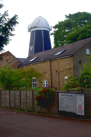
FRENCH'S ROAD
1.
942
Windmill at
Chesterton Mills
TL 4459 15/497
II
2.
Early C19. Smockmill. Tower circa 50' high. Gault brick base with weather-
boarding above. Cap remaining, but sails and tailfan missing.
Listing NGR: TL4455859947
External links are from the relevant listing authority and, where applicable, Wikidata. Wikidata IDs may be related buildings as well as this specific building. If you want to add or update a link, you will need to do so by editing the Wikidata entry.


Other nearby listed buildings
