Approximate Location Map
Large Map »
Latitude: 53.2126 / 53°12'45"N
Longitude: -1.5994 / 1°35'57"W
OS Eastings: 426848
OS Northings: 368469
OS Grid: SK268684
Mapcode National: GBR 57W.QF7
Mapcode Global: WHCD8.DJL0
Plus Code: 9C5W6C72+26
Entry Name: Beeley Hilltop Farm Cottage and Attached Outbuildings
Listing Date: 12 July 1967
Grade: II
Source: Historic England
Source ID: 1338875
English Heritage Legacy ID: 81595
ID on this website: 101338875
Location: Derbyshire Dales, Derbyshire, DE4
County: Derbyshire
District: Derbyshire Dales
Civil Parish: Beeley
Traditional County: Derbyshire
Lieutenancy Area (Ceremonial County): Derbyshire
Church of England Parish: Beeley St Anne
Church of England Diocese: Derby
Tagged with: Cottage
PARISH OF BEELEY OFF CHATSWORTH ROAD
SK 26 NE
5/30
(East Side)
12.7.67 Beeley Hilltop Farm
Cottage and Attached
Outbuildings
II
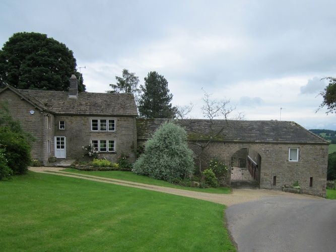
House and attached outbuildings. C18 and C19, altered C20.
Coursed rubble sandstone with sandstone dressings. Stone slate
roof with brick ridge and gable stacks and two stone stacks in
the pitch of the roof. Two storey. L-plan. House forms most
of the south wing and is in itself L-plan. East elevation has a
doorway in the angle, with C20 half glazed door. To the left a
large 2-light window and to the right a large 3-light window,
both with square section flush mullions. Two similar windows
above and a single light over the door. West elevation of five
bays. Off-centre doorway with stone jambs and lintel and
bracketed stone hood. To the right a 2-light casement window
with massive stone lintel and jambs. To the left a 3-light and
a 2-light casement window with massive stone lintel and jambs.
To the left a 3-light and a 2-light square section flush mullion
window. Two similar 3-light windows and a similar 2-light
window above. Lower range to north now partly incorporated into
the house. Segmental arched cart entrance into the courtyard.
Long return range of outbuildings under continuous roof. Blind
to north. To south C20 garage openings and three square windows
above.
Listing NGR: SK2684868469
External links are from the relevant listing authority and, where applicable, Wikidata. Wikidata IDs may be related buildings as well as this specific building. If you want to add or update a link, you will need to do so by editing the Wikidata entry.


Other nearby listed buildings
