Approximate Location Map
Large Map »
Latitude: 51.3309 / 51°19'51"N
Longitude: -1.2322 / 1°13'55"W
OS Eastings: 453591
OS Northings: 159367
OS Grid: SU535593
Mapcode National: GBR 946.F9D
Mapcode Global: VHCZS.LTG3
Plus Code: 9C3W8QJ9+94
Entry Name: Cartshed 10 Yards East of Knowl Farmhouse
Listing Date: 18 May 1984
Grade: II
Source: Historic England
Source ID: 1339770
English Heritage Legacy ID: 138284
ID on this website: 101339770
Location: Basingstoke and Deane, Hampshire, RG20
County: Hampshire
District: Basingstoke and Deane
Town: Basingstoke and Deane
Civil Parish: Kingsclere
Traditional County: Hampshire
Lieutenancy Area (Ceremonial County): Hampshire
Church of England Parish: Kingsclere
Church of England Diocese: Winchester
Tagged with: Carriage house
SU 55 NW KINGSCLERE
8/27
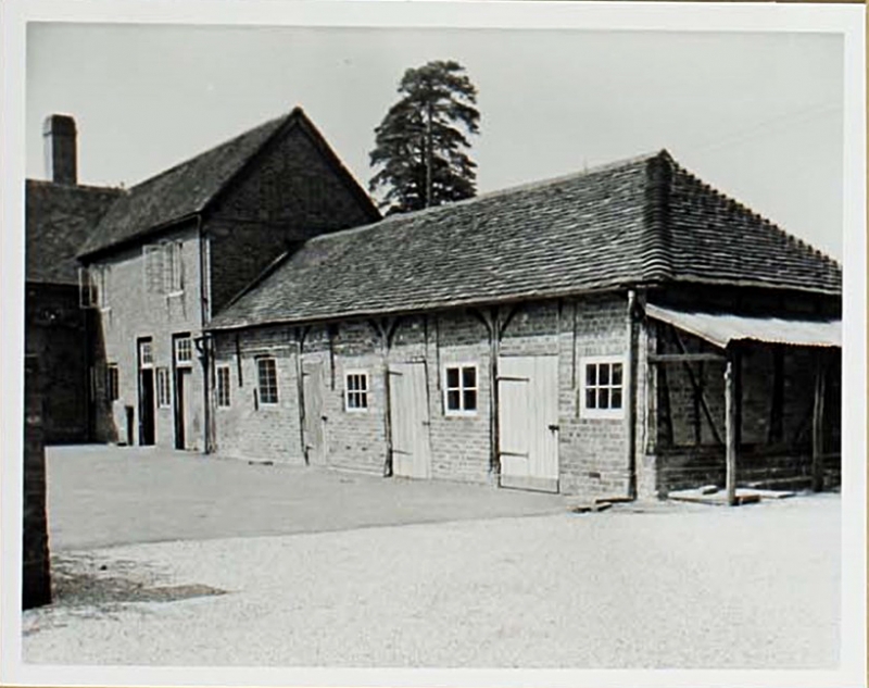
Cartshed 10 yds east
of Knowl Farmhouse
GV
II
Early C19. Timber-frame of 5 bays. Later slate roof of lowered pitch. The walling
is part boarded part bricknogged frame.
Listing NGR: SU5283757840
External links are from the relevant listing authority and, where applicable, Wikidata. Wikidata IDs may be related buildings as well as this specific building. If you want to add or update a link, you will need to do so by editing the Wikidata entry.


Other nearby listed buildings
