Approximate Location Map
Large Map »
Latitude: 50.8447 / 50°50'41"N
Longitude: -0.9367 / 0°56'12"W
OS Eastings: 474957
OS Northings: 105563
OS Grid: SU749055
Mapcode National: GBR CF1.XPP
Mapcode Global: FRA 86XV.YQK
Plus Code: 9C2XR3V7+V8
Entry Name: Sea View House
Listing Date: 21 July 1975
Grade: II
Source: Historic England
Source ID: 1339955
English Heritage Legacy ID: 135522
ID on this website: 101339955
Location: Emsworth, Havant, Hampshire, PO10
County: Hampshire
District: Havant
Electoral Ward/Division: Emsworth
Parish: Non Civil Parish
Built-Up Area: Emsworth
Traditional County: Hampshire
Lieutenancy Area (Ceremonial County): Hampshire
Church of England Parish: Warblington St Thomas a Becket
Church of England Diocese: Portsmouth
Tagged with: House
SU 7405 HAVANT TOWER STREET
Emsworth
21.7.75
11/41 No. 23 (Sea View House)
II
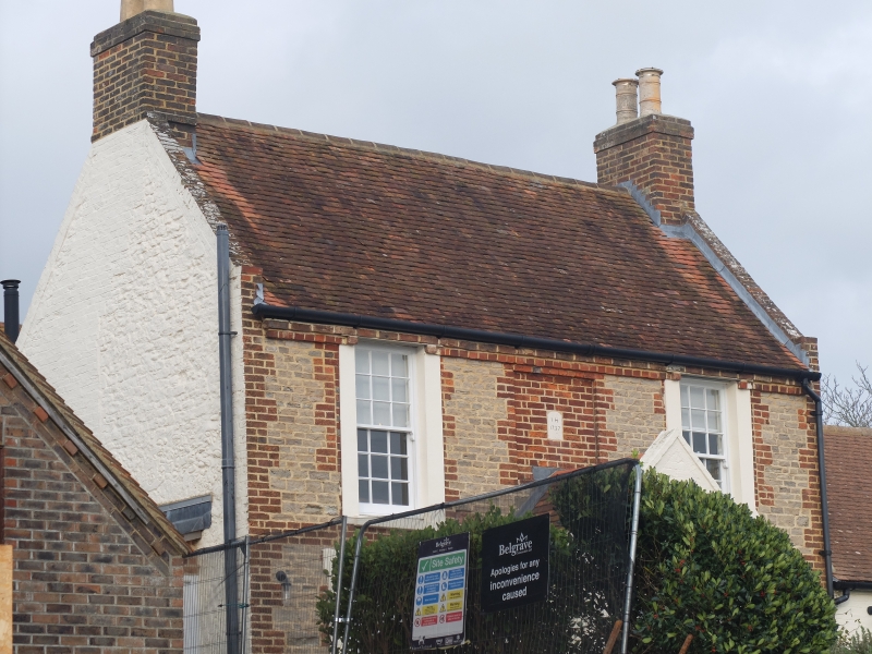
House. 1727. Stone and brick, with a tile roof. Symmetrical front of
2 storeys, 3 windows (middle blank). Rough ashlar walling with red brick
quoins and panel, cement plain architraves. Sashes in reveals. C19 gabled
brick porch. Dated plaque.
Listing NGR: SU7373608059
External links are from the relevant listing authority and, where applicable, Wikidata. Wikidata IDs may be related buildings as well as this specific building. If you want to add or update a link, you will need to do so by editing the Wikidata entry.


Other nearby listed buildings
