Approximate Location Map
Large Map »
Latitude: 50.9123 / 50°54'44"N
Longitude: -1.4066 / 1°24'23"W
OS Eastings: 441812
OS Northings: 112708
OS Grid: SU418127
Mapcode National: GBR RQB.NN
Mapcode Global: FRA 76YP.MT7
Plus Code: 9C2WWH6V+W9
Entry Name: 81A, Bedford Place
Listing Date: 8 October 1981
Grade: II
Source: Historic England
Source ID: 1339979
English Heritage Legacy ID: 135718
ID on this website: 101339979
Location: Bedford Place, Southampton, Hampshire, SO15
County: City of Southampton
Electoral Ward/Division: Bargate
Parish: Non Civil Parish
Built-Up Area: Southampton
Traditional County: Hampshire
Lieutenancy Area (Ceremonial County): Hampshire
Church of England Parish: Southampton City Centre St Mary
Church of England Diocese: Winchester
Tagged with: Building
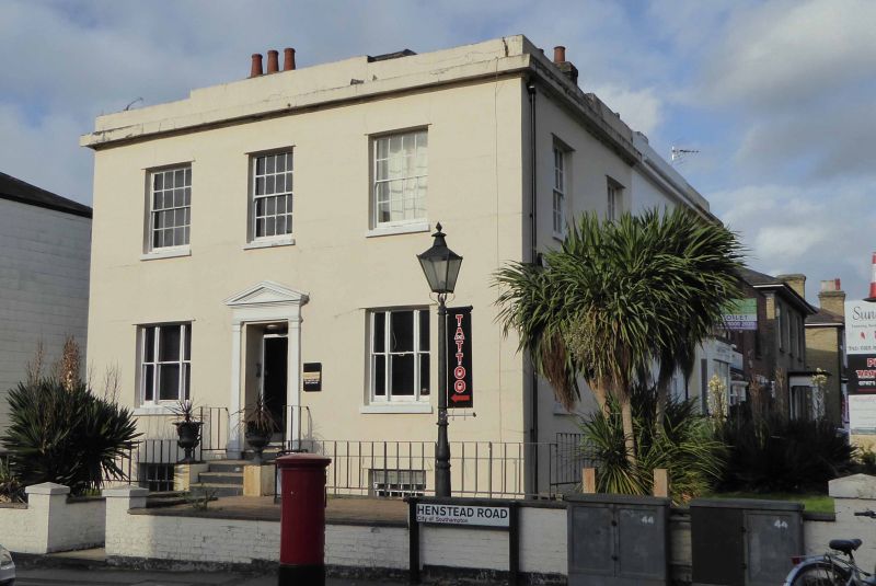
1. BEDFORD PLACE
5239 (west side)
No 81A
SU 4112 1/25
II
2.
Early to mid-C19. Two storeys attics and basement rendered. Hipped slate
roof with one dormer. Parapet with raised band in centre. Moulded eaves
cornice. Three sashes with glazing bars intact to first floor. Open pedimented
doorcase.
Listing NGR: SU4181212708
External links are from the relevant listing authority and, where applicable, Wikidata. Wikidata IDs may be related buildings as well as this specific building. If you want to add or update a link, you will need to do so by editing the Wikidata entry.


Other nearby listed buildings
