Approximate Location Map
Large Map »
Latitude: 51.6793 / 51°40'45"N
Longitude: -2.174 / 2°10'26"W
OS Eastings: 388068
OS Northings: 197854
OS Grid: ST880978
Mapcode National: GBR 1ND.P5Z
Mapcode Global: VH95C.81KY
Plus Code: 9C3VMRHG+PC
Entry Name: Rodways Cottage and Rodways Place
Listing Date: 6 September 1954
Grade: II
Source: Historic England
Source ID: 1341588
English Heritage Legacy ID: 128306
ID on this website: 101341588
Location: Avening, Cotswold, Gloucestershire, GL8
County: Gloucestershire
District: Cotswold
Civil Parish: Avening
Built-Up Area: Avening
Traditional County: Gloucestershire
Lieutenancy Area (Ceremonial County): Gloucestershire
Church of England Parish: Avening Holy Cross
Church of England Diocese: Gloucester
Tagged with: Building
This list entry was subject to a Minor Amendment on 20 April 2023 to amend the name and address and to reformat the text to current standards
ST 89 NE
3/30
AVENING
POINT ROAD (south side)
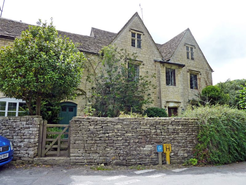
Rodways Cottage (No 25) and Rodways Place
(Formerly listed as No. 25)
6.9.54
II
Detached house, incorporating former service wing to left at time of listing. Late C17, restored substantially in C19. Random coursed rubble stone, Cotswold stone slate roof, flush stone quoins. Central stone ridge stack set diagonally and gable stack to left hand wing. Single range with two cross gables. Two storeys and attic. Shallow two-storey central projection surmounted by ball finial, with doorway on ground floor having moulded stone jambs and lintel and Tudor hood mould under bearing arch, with one two-light leaded casement above with moulded stone frame and hood mould. Ground and first floor have similar windows to either side and gables have two-light stone windows with mullion and transom, all with bearing arches. Left hand wing of two storeys, two windows, casements under shallow arches, converted to domestic use.
Listing NGR: ST8806897854
External links are from the relevant listing authority and, where applicable, Wikidata. Wikidata IDs may be related buildings as well as this specific building. If you want to add or update a link, you will need to do so by editing the Wikidata entry.


Other nearby listed buildings
