Approximate Location Map
Large Map »
Latitude: 51.783 / 51°46'58"N
Longitude: 0.0002 / 0°0'0"E
OS Eastings: 538070
OS Northings: 211266
OS Grid: TL380112
Mapcode National: GBR KC1.0W8
Mapcode Global: VHGPP.YFGZ
Plus Code: 9F32Q2M2+63
Entry Name: St Margarets Farm House
Listing Date: 30 September 1983
Grade: II
Source: Historic England
Source ID: 1341858
English Heritage Legacy ID: 355979
ID on this website: 101341858
Location: St Margarets, East Hertfordshire, SG12
County: Hertfordshire
District: East Hertfordshire
Civil Parish: Stanstead St Margarets
Built-Up Area: St Margarets
Traditional County: Hertfordshire
Lieutenancy Area (Ceremonial County): Hertfordshire
Church of England Parish: Great Amwell with St Margaret's
Church of England Diocese: St.Albans
Tagged with: Farmhouse
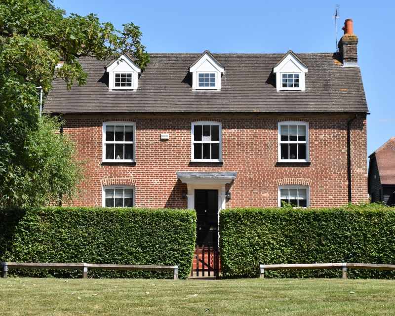
TL 3811 STANSTEAD HODDESDON ROAD
ST MARGARETS (west side)
St Margarets village
13/35 No 102
(St Margarets Farm house)
GV II
Farmhouse. C18. Red brick with scattered black headers. Steep
tiled gable roofs. Slate lean-to in angle at rear. A large L-
shaped house facing S. 2-storeys, attics and basement. Internal
gable chimneys. Symmetrical 3-window front and 3 gable dormers
on roofslope. Recessed sash windows under segmental arches with
6/6 panes. Cellar windows blocked. Central half-glazed double
doors with margin panes up 5 steps with pilastered surround and
stepped moulded brackets supporting a large flat moulded hood.
Blind recesses along hipped rear wing on wall facing road.
Slated lean-to extension with casement windows fill angle between
wings. A large brick period farmhouse little altered.
Listing NGR: TL3807011266
External links are from the relevant listing authority and, where applicable, Wikidata. Wikidata IDs may be related buildings as well as this specific building. If you want to add or update a link, you will need to do so by editing the Wikidata entry.


Other nearby listed buildings
