Approximate Location Map
Large Map »
Latitude: 52.5156 / 52°30'56"N
Longitude: -2.085 / 2°5'5"W
OS Eastings: 394328
OS Northings: 290860
OS Grid: SO943908
Mapcode National: GBR 4PC.QM
Mapcode Global: VH91B.T13C
Plus Code: 9C4VGW88+62
Entry Name: Priory Ruins
Listing Date: 14 September 1949
Grade: I
Source: Historic England
Source ID: 1343217
English Heritage Legacy ID: 217984
Also known as: St James's Priory
ID on this website: 101343217
Location: Priory Park, Priory, Dudley, West Midlands, DY1
County: Dudley
Electoral Ward/Division: Castle and Priory
Parish: Non Civil Parish
Built-Up Area: Dudley (Dudley)
Traditional County: Staffordshire
Lieutenancy Area (Ceremonial County): West Midlands
Church of England Parish: Dudley St Edmund King and Martyr
Church of England Diocese: Worcester
Tagged with: Priory
1.
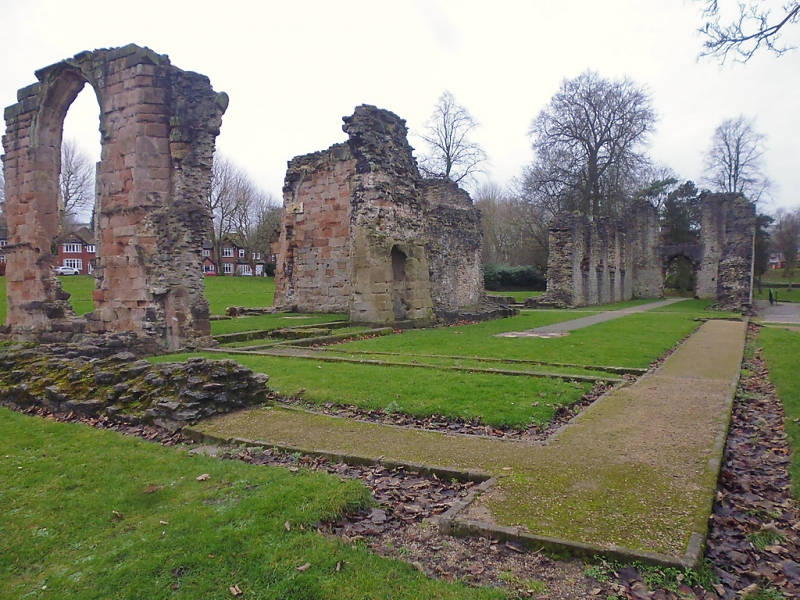
5106 PRIORY PARK
Priory Ruins
SO 9490 NW 3/44 14.9.49
I
2.
Founded 1160 as a dependency of the Cluniac Priory of Much Wenlock. Limestone
rubble. Some fragments of the conventual church remain with some exposed tiled
pavements. Foundations of claustral buildings. AM.
Listing NGR: SO9433090847
External links are from the relevant listing authority and, where applicable, Wikidata. Wikidata IDs may be related buildings as well as this specific building. If you want to add or update a link, you will need to do so by editing the Wikidata entry.


Other nearby listed buildings
