Approximate Location Map
Large Map »
Latitude: 51.273 / 51°16'22"N
Longitude: 1.341 / 1°20'27"E
OS Eastings: 633129
OS Northings: 157955
OS Grid: TR331579
Mapcode National: GBR X18.3TX
Mapcode Global: VHLGS.688F
Plus Code: 9F3378FR+69
Entry Name: Sackville House
Listing Date: 29 April 1970
Grade: II
Source: Historic England
Source ID: 1343781
English Heritage Legacy ID: 177571
ID on this website: 101343781
Location: Sandwich, Dover, Kent, CT13
County: Kent
District: Dover
Civil Parish: Sandwich
Built-Up Area: Sandwich
Traditional County: Kent
Lieutenancy Area (Ceremonial County): Kent
Tagged with: House
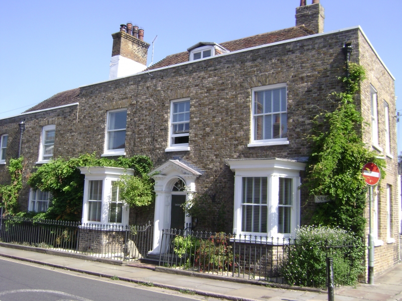
1.
5275 NEW STREET
(North East Side)
No 53
(Sackville House)
TR 3357 NW 2/83 29.4.70.
II GV
2.
Early C19 2 storey and attic. 5 windows, one dormer with pediment. Brown
brick, parapet with tiled roof behind. 2 bay windows on ground floor. Glazing
bars missing. Doorway with Doric three-quarters columns, pediment, semi-circular
fanlight and 6 panel fielded door.
No 53 with Nos 1 to 5 (odd) Galliard Street form a group.
Listing NGR: TR3312757959
External links are from the relevant listing authority and, where applicable, Wikidata. Wikidata IDs may be related buildings as well as this specific building. If you want to add or update a link, you will need to do so by editing the Wikidata entry.


Other nearby listed buildings
