Approximate Location Map
Large Map »
Latitude: 51.3449 / 51°20'41"N
Longitude: 0.7625 / 0°45'45"E
OS Eastings: 592490
OS Northings: 164271
OS Grid: TQ924642
Mapcode National: GBR RT7.MLV
Mapcode Global: VHKJM.5GGB
Plus Code: 9F328QV7+X2
Entry Name: East Hall
Listing Date: 10 September 1951
Grade: II
Source: Historic England
Source ID: 1344246
English Heritage Legacy ID: 175802
ID on this website: 101344246
Location: Murston, Swale, Kent, ME10
County: Kent
District: Swale
Electoral Ward/Division: Murston
Parish: Non Civil Parish
Built-Up Area: Sittingbourne
Traditional County: Kent
Lieutenancy Area (Ceremonial County): Kent
Tagged with: House
1.
5282 MURSTON
East Hall
TQ 96 SW 9/51 10.9.51.
II
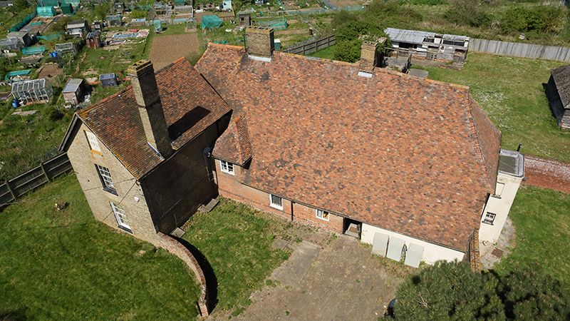
2.
A large timber-framed house, of which the main front faces North. 2 storeys and
attics plastered. Tiled roof with pentice behind. 3 dormers. The 1st floor oversails
on a bressumer and brackets. 5 casement windows. L-wing in brown brick added
at the West end in the C19. Roof slopes to ground floor at rear.
Listing NGR: TQ9249064271
External links are from the relevant listing authority and, where applicable, Wikidata. Wikidata IDs may be related buildings as well as this specific building. If you want to add or update a link, you will need to do so by editing the Wikidata entry.


Other nearby listed buildings
