Approximate Location Map
Large Map »
Latitude: 51.1742 / 51°10'27"N
Longitude: 0.4946 / 0°29'40"E
OS Eastings: 574478
OS Northings: 144617
OS Grid: TQ744446
Mapcode National: GBR PSB.CW0
Mapcode Global: VHJMS.JRB7
Plus Code: 9F325FFV+MR
Entry Name: Railings About 3 Metres East of Shepherd's House
Listing Date: 23 March 1987
Grade: II
Source: Historic England
Source ID: 1344420
English Heritage Legacy ID: 174719
ID on this website: 101344420
Location: Marden, Maidstone, Kent, TN12
County: Kent
District: Maidstone
Civil Parish: Marden
Built-Up Area: Marden
Traditional County: Kent
Lieutenancy Area (Ceremonial County): Kent
Tagged with: Guard rail
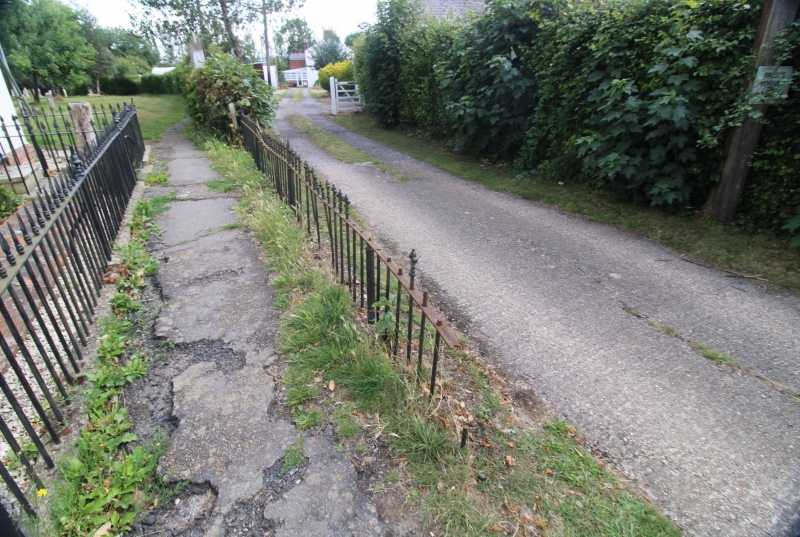
TQ 7444 MARDEN HIGH STREET
(north side)
5/61 Railings about 3
metres east of
Shepherd's House
GV II
Railings. C19. Painted iron. Fleur-de-lys railings and newels
about 1 metre high, running north from street for about 15 metres.
Delineate eastern edge of a footpath between street and
churchyard. Included for group value. See also item 5/60.
Listing NGR: TQ7447744613
External links are from the relevant listing authority and, where applicable, Wikidata. Wikidata IDs may be related buildings as well as this specific building. If you want to add or update a link, you will need to do so by editing the Wikidata entry.


Other nearby listed buildings
