Approximate Location Map
Large Map »
Latitude: 51.2337 / 51°14'1"N
Longitude: 0.4083 / 0°24'29"E
OS Eastings: 568228
OS Northings: 151031
OS Grid: TQ682510
Mapcode National: GBR NQ4.N14
Mapcode Global: VHJMK.1863
Plus Code: 9F326CM5+F8
Entry Name: Brymeade Green Farm Cottage
Listing Date: 14 October 1987
Grade: II
Source: Historic England
Source ID: 1344437
English Heritage Legacy ID: 174809
ID on this website: 101344437
Location: Nettlestead Green, Maidstone, Kent, ME18
County: Kent
District: Maidstone
Civil Parish: Nettlestead
Traditional County: Kent
Lieutenancy Area (Ceremonial County): Kent
Church of England Parish: Nettlestead St Mary the Virgin
Church of England Diocese: Rochester
Tagged with: Cottage
NETTLESTEAD MAIDSTONE ROAD
TQ 65 SE
(East side)
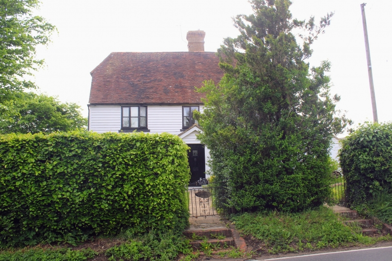
1/10 Green Farm Cottage
and Brymeade
II
House, now house pair. Early C18 or (probably) earlier. Ground floor
rendered, first floor pebbledashed, probably over timber framing. Plain
tile roof. 2 storeys. Stepply-pitched half-hipped roof. Rendered stack
in rear slope of roof towards centre. Projecting gable end stack to
right, now within right gable-end lean-to. Irregular fenestration of 3
two-light casements. Panelled door with flat bracketed hood under stack,
to Brymede. Rear door to right to Green Farm Cottage. Two-storey parallel
rear addition with hipped plain-tile roof with lower ridge than main range.
Interior not inspected. Axial beam of relatively heavy scantling visible
in left ground-floor room.
Listing NGR: TQ6822851030
External links are from the relevant listing authority and, where applicable, Wikidata. Wikidata IDs may be related buildings as well as this specific building. If you want to add or update a link, you will need to do so by editing the Wikidata entry.


Other nearby listed buildings
