Approximate Location Map
Large Map »
Latitude: 53.8411 / 53°50'27"N
Longitude: -0.4252 / 0°25'30"W
OS Eastings: 503714
OS Northings: 439462
OS Grid: TA037394
Mapcode National: GBR TSG0.QT
Mapcode Global: WHGF4.FQR7
Plus Code: 9C5XRHRF+CW
Entry Name: 13, Eastgate
Listing Date: 30 June 1987
Grade: II
Source: Historic England
Source ID: 1346323
English Heritage Legacy ID: 167140
ID on this website: 101346323
Location: Beverley, East Riding of Yorkshire, HU17
County: East Riding of Yorkshire
Civil Parish: Beverley
Built-Up Area: Beverley
Traditional County: Yorkshire
Lieutenancy Area (Ceremonial County): East Riding of Yorkshire
Church of England Parish: Beverley Minster St John and St Martin
Church of England Diocese: York
Tagged with: Building
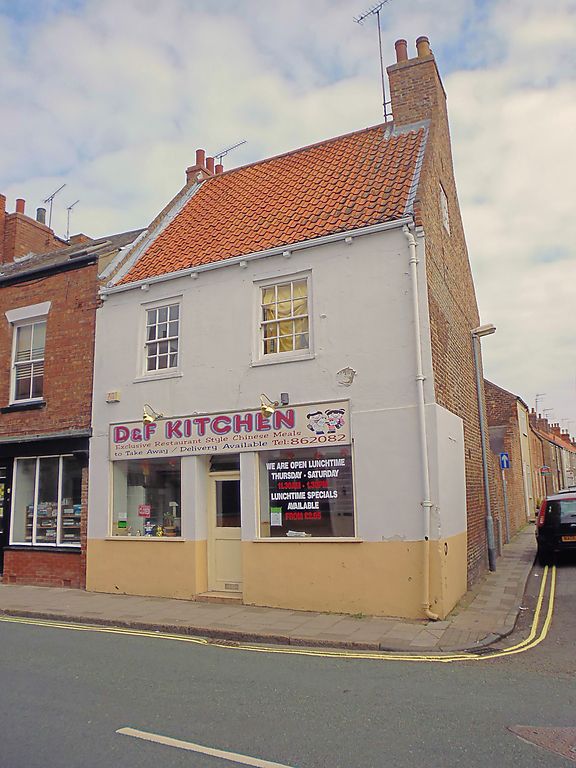
BEVERLEY EASTGATE
TA 0339 (east side)
10/41
- No 13
GV II
C18. Brick, stucco-fronted. Pantile roof. Coped gables with brick tumbling.
Two storeys. Two bays. Cased C19 sashes: modern windows on ground floor.
Listing NGR: TA0371439462
External links are from the relevant listing authority and, where applicable, Wikidata. Wikidata IDs may be related buildings as well as this specific building. If you want to add or update a link, you will need to do so by editing the Wikidata entry.


Other nearby listed buildings
