Approximate Location Map
Large Map »
Latitude: 52.4008 / 52°24'2"N
Longitude: -2.2705 / 2°16'13"W
OS Eastings: 381692
OS Northings: 278123
OS Grid: SO816781
Mapcode National: GBR 0B7.GSJ
Mapcode Global: VH91M.LXJD
Plus Code: 9C4VCP2H+8R
Entry Name: 4, 5 and 6, Bridgnorth Road
Listing Date: 3 October 1978
Grade: II
Source: Historic England
Source ID: 1348621
English Heritage Legacy ID: 156417
ID on this website: 101348621
Location: Franche, Wyre Forest, Worcestershire, DY11
County: Worcestershire
District: Wyre Forest
Civil Parish: Kidderminster
Built-Up Area: Kidderminster
Traditional County: Worcestershire
Lieutenancy Area (Ceremonial County): Worcestershire
Church of England Parish: Kidderminster Ismere
Church of England Diocese: Worcester
Tagged with: Building
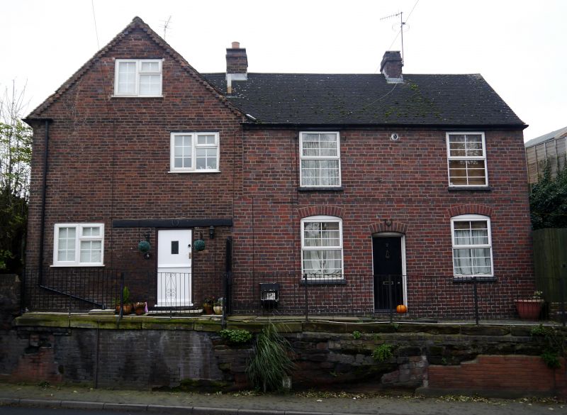
BRIDGNORTH ROAD
1.
5250 (west side)
Nos 4, 5 and 6
SO 87 NW 2/95 3.10.78
II
2.
Early to mid-C18. Two storey, red brick house. No 4 is a slightly later 2-bay
extension and No 6 forms a lower gabled wing with mid C19 extension on terrace
above road. Originally one house, the extension in the mid-C18 of No 4 resulted
in sub-division and the wing was created as a separate unit at the time of the
mid-C19 addition. Brick dentil eaves cornice to hipped tile roof over the main
block. Similar dentil eaves and tiles to gabled wing. Four windows to main
block of Nos 4 and 5, one to wing - C19 3-light casements in original openings
with flat gauged brick arches. Doorways altered with modern glazed porches.
Tall brick C19 chimney stack at junction of gabled wing with No 5. C18 chimneys
on ridge of main block and external chimney to side of No 4. Internally, No
4 has simple dog leg turned baluster staircase and chamfered ceiling beams.
Listing NGR: SO8169278123
External links are from the relevant listing authority and, where applicable, Wikidata. Wikidata IDs may be related buildings as well as this specific building. If you want to add or update a link, you will need to do so by editing the Wikidata entry.


Other nearby listed buildings
