Approximate Location Map
Large Map »
Latitude: 51.2887 / 51°17'19"N
Longitude: 0.4322 / 0°25'56"E
OS Eastings: 569698
OS Northings: 157201
OS Grid: TQ696572
Mapcode National: GBR NPL.243
Mapcode Global: VHJM5.FVWZ
Plus Code: 9F327CQJ+FV
Entry Name: Weir Mill
Listing Date: 15 November 1973
Grade: II
Source: Historic England
Source ID: 1348690
English Heritage Legacy ID: 179343
ID on this website: 101348690
Location: Mill Street, Tonbridge and Malling, Kent, ME19
County: Kent
District: Tonbridge and Malling
Civil Parish: East Malling and Larkfield
Built-Up Area: Ditton
Traditional County: Kent
Lieutenancy Area (Ceremonial County): Kent
Church of England Parish: East Malling St James
Church of England Diocese: Rochester
Tagged with: Mill
EAST MALLING & LARKFIELD MILL STREET
TQ 65 NE
(south side)
7/169
15.11.73 Weir Mill
- II
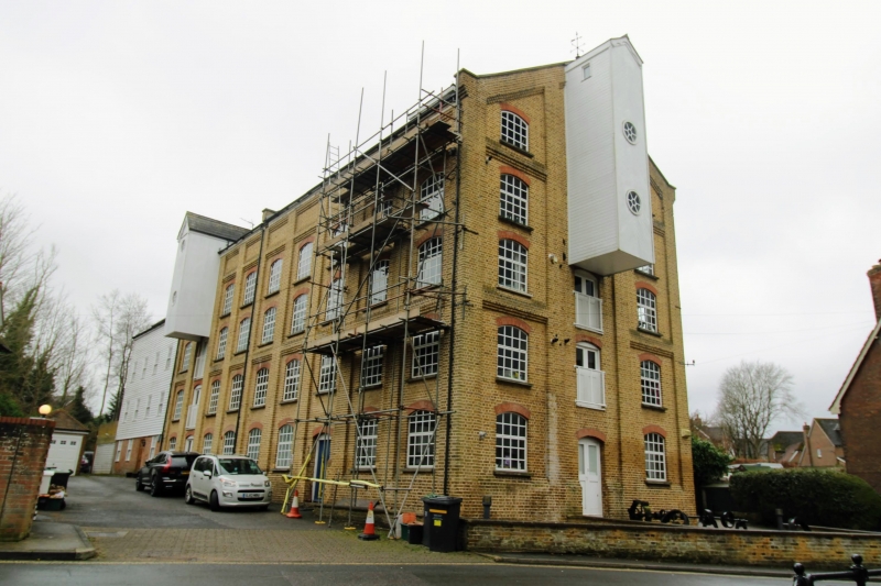
Paper Mill. C18 and circa 1900. Built in two parts, the earlier to the rear.
REAR PORTION: Ground floor of red brick with grey headers, 2 upper floors
weather-boarded. Left side 2 glazing bar sash elevation with 2 industrial doors
below. Right side, upper storey only weather-boarded. 4 glazing bar sash
elevation. South end gabled with 1 glazing bar sash window. Mill wheel.
Interior carried on square wooden supports. FRONT PORTION: Red brick with slate
roof. 4 pilasters through all floors. 2 metal-framed cambered windows with
cambered brick heads. Tall central weather-boarded lucarne with 2 round windows
and curved wooden bargeboards. 3 industrial doors. Weather-boarded belvedere
on roof. Left side with 8 windows and similar weather-boarded lucarne. 3-storey
matching extension attached to right side. Sources: Michael T Fullan, The
Watermills of the East Malling and Wateringbury Streams, Maidstone, 1980.
Listing NGR: TQ6969857201
External links are from the relevant listing authority and, where applicable, Wikidata. Wikidata IDs may be related buildings as well as this specific building. If you want to add or update a link, you will need to do so by editing the Wikidata entry.


Other nearby listed buildings
