Approximate Location Map
Large Map »
Latitude: 52.1636 / 52°9'48"N
Longitude: -2.2464 / 2°14'47"W
OS Eastings: 383239
OS Northings: 251726
OS Grid: SO832517
Mapcode National: GBR 1GH.8W2
Mapcode Global: VH92T.0WR9
Plus Code: 9C4V5Q73+CC
Entry Name: Powyke House
Listing Date: 9 February 1988
Grade: II
Source: Historic England
Source ID: 1349276
English Heritage Legacy ID: 153410
ID on this website: 101349276
Location: Powick Village, Malvern Hills, Worcestershire, WR2
County: Worcestershire
District: Malvern Hills
Civil Parish: Powick
Built-Up Area: Powick
Traditional County: Worcestershire
Lieutenancy Area (Ceremonial County): Worcestershire
Church of England Parish: Powick
Church of England Diocese: Worcester
Tagged with: House
POWICK CP A 449
SO 85 SW
3/92
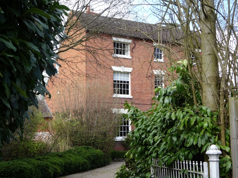
Powyke House
- II
House. Early C19. Brick in Flemish bond with tile roof. Three storeys,
three bays. Windows are sashed with glazing bars and have painted stone
lintels with keystones. The doorway, in the central bay, has a round head
with fanlight and an open pediment on consoles; panelled door. Chimneys
behind ridge.
Listing NGR: SO8323951726
External links are from the relevant listing authority and, where applicable, Wikidata. Wikidata IDs may be related buildings as well as this specific building. If you want to add or update a link, you will need to do so by editing the Wikidata entry.


Other nearby listed buildings
