Approximate Location Map
Large Map »
Latitude: 52.0912 / 52°5'28"N
Longitude: -1.956 / 1°57'21"W
OS Eastings: 403112
OS Northings: 243655
OS Grid: SP031436
Mapcode National: GBR 3L9.Y0G
Mapcode Global: VHB0T.1PTQ
Plus Code: 9C4W32RV+FJ
Entry Name: Abbot Chyryton's Wall
Listing Date: 24 June 1977
Grade: II
Source: Historic England
Source ID: 1350435
English Heritage Legacy ID: 147386
ID on this website: 101350435
Location: Evesham, Wychavon, Worcestershire, WR11
County: Worcestershire
District: Wychavon
Civil Parish: Evesham
Built-Up Area: Evesham
Traditional County: Worcestershire
Lieutenancy Area (Ceremonial County): Worcestershire
Church of England Parish: Evesham All Saints with St Lawrence
Church of England Diocese: Worcester
Tagged with: Architectural structure
BOAT LANE
1.
5249
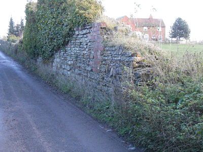
Abbot Chyryton's Wall
SP 0343 4/110
II
2.
Remains of medieval wall. Rubble. Approximately 300 ft in length and of an average
height of about 3 ft.
Listing NGR: SP0311243655
External links are from the relevant listing authority and, where applicable, Wikidata. Wikidata IDs may be related buildings as well as this specific building. If you want to add or update a link, you will need to do so by editing the Wikidata entry.


Other nearby listed buildings
