Approximate Location Map
Large Map »
Latitude: 50.96 / 50°57'36"N
Longitude: -0.5085 / 0°30'30"W
OS Eastings: 504844
OS Northings: 118903
OS Grid: TQ048189
Mapcode National: GBR GJ7.Q8K
Mapcode Global: FRA 96TK.XBP
Plus Code: 9C2XXF6R+2J
Entry Name: Wayside
Listing Date: 9 May 1980
Grade: II
Source: Historic England
Source ID: 1354005
English Heritage Legacy ID: 298554
ID on this website: 101354005
Location: Pulborough, Horsham, West Sussex, RH20
County: West Sussex
District: Horsham
Civil Parish: Pulborough
Built-Up Area: West Chiltington Common
Traditional County: Sussex
Lieutenancy Area (Ceremonial County): West Sussex
Church of England Parish: Pulborough St Mary
Church of England Diocese: Chichester
Tagged with: Building
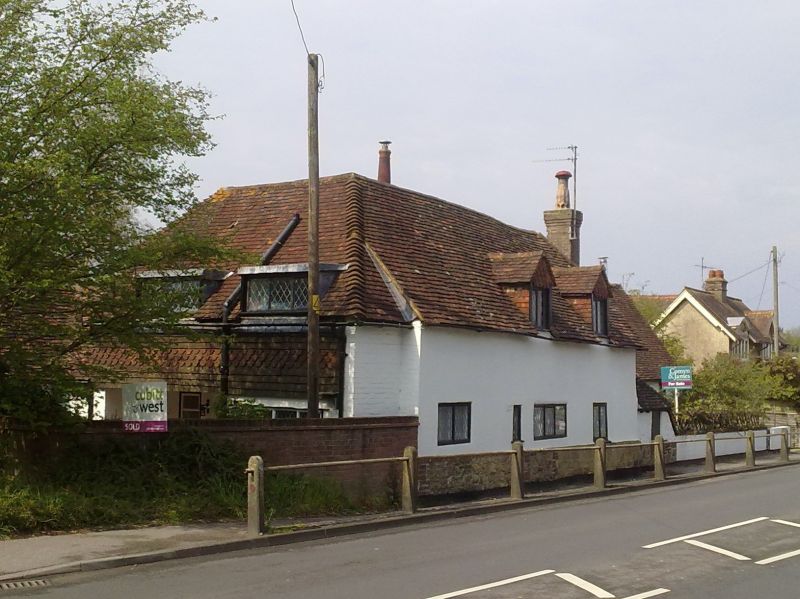
PULBOROUGH LONDON ROAD
1.
5404
Wayside
TQ 0418 17/733
II
2.
C17 timber-framed cottage faced with roughcast. Hipped tiled roof. Casement windows.
Chimney breast at north-east end. One storey and attic. Two windows. Two gabled
dormers.
Listing NGR: TQ0484118904
External links are from the relevant listing authority and, where applicable, Wikidata. Wikidata IDs may be related buildings as well as this specific building. If you want to add or update a link, you will need to do so by editing the Wikidata entry.


Other nearby listed buildings
