Approximate Location Map
Large Map »
Latitude: 50.8364 / 50°50'10"N
Longitude: -0.7757 / 0°46'32"W
OS Eastings: 486307
OS Northings: 104806
OS Grid: SU863048
Mapcode National: GBR DGS.GQH
Mapcode Global: FRA 968W.FMJ
Plus Code: 9C2XR6PF+GP
Entry Name: 39, East Street
Listing Date: 8 October 1971
Grade: II
Source: Historic England
Source ID: 1354280
English Heritage Legacy ID: 299881
ID on this website: 101354280
Location: Chichester, West Sussex, PO19
County: West Sussex
District: Chichester
Civil Parish: Chichester
Built-Up Area: Chichester
Traditional County: Sussex
Lieutenancy Area (Ceremonial County): West Sussex
Church of England Parish: Chichester St Pancras
Church of England Diocese: Chichester
Tagged with: Building
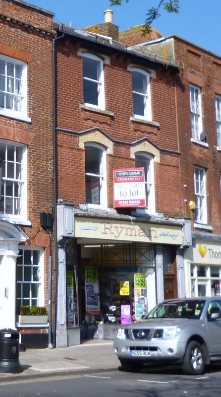
EAST STREET
1.
972
(North Side)
No 39
SU 8604 NW 4/601
II
2.
Mid C19. 3 storeys. 2 windows. Red brick. Stringcourse of pointed
brick ornamentation above the first and second floor. Eaves bracket
cornice. Tiled roof. Glazing bars missing. Modern shop fronts.
Listing NGR: SU8630804807
External links are from the relevant listing authority and, where applicable, Wikidata. Wikidata IDs may be related buildings as well as this specific building. If you want to add or update a link, you will need to do so by editing the Wikidata entry.


Other nearby listed buildings
