Approximate Location Map
Large Map »
Latitude: 54.9064 / 54°54'23"N
Longitude: -1.3777 / 1°22'39"W
OS Eastings: 439998
OS Northings: 557034
OS Grid: NZ399570
Mapcode National: GBR VDB.C4
Mapcode Global: WHD55.TY41
Plus Code: 9C6WWJ4C+HW
Entry Name: Number 19 and Attached Wall, Railings and Area Cover
Listing Date: 10 November 1978
Last Amended: 17 October 1994
Grade: II
Source: Historic England
Source ID: 1355049
English Heritage Legacy ID: 391537
ID on this website: 101355049
Location: Sunderland, Tyne and Wear, SR1
County: Sunderland
Electoral Ward/Division: Hendon
Parish: Non Civil Parish
Built-Up Area: Sunderland
Traditional County: Durham
Lieutenancy Area (Ceremonial County): Tyne and Wear
Church of England Parish: Hendon
Church of England Diocese: Durham
Tagged with: Building
SUNDERLAND
NZ3957SE NORFOLK STREET
920-1/18/156 (East side)
10/11/78 No.19
and attached wall, railings and area
cover
(Formerly Listed as:
NORFOLK STREET
(East side)
No.19)
GV II
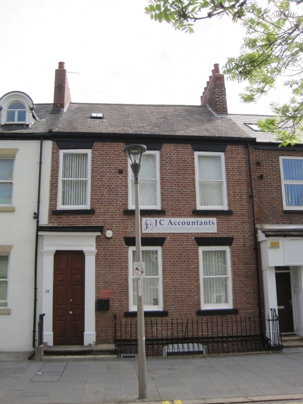
House, part of a terrace, now offices, with dwarf wall,
railings and area cover attached. c1840. Painted brick with
painted ashlar dressings; Welsh slate roof with brick chimney;
wrought-iron railings and area cover. 2 storeys and basement,
3 windows. Altered steps to panelled door at left of
Sunderland type, folding back to form reveals to inner
half-glazed door with plain overlight; doorcase of Tuscan
pilasters and entablature with shallow dentils to frieze.
Wedge stone lintels and projecting stone sills to renewed
plain sashes. Roof has transverse-ridge chimney at right.
Handrail with ramped spiral end and part balustrade retained
when steps altered. Curved area cover behind spike-headed
railings on dwarf wall between balustrade and end railings
also with ramped top rail.
Listing NGR: NZ3999857034
External links are from the relevant listing authority and, where applicable, Wikidata. Wikidata IDs may be related buildings as well as this specific building. If you want to add or update a link, you will need to do so by editing the Wikidata entry.


Other nearby listed buildings
