Approximate Location Map
Large Map »
Latitude: 54.9706 / 54°58'14"N
Longitude: -1.6154 / 1°36'55"W
OS Eastings: 424715
OS Northings: 564065
OS Grid: NZ247640
Mapcode National: GBR SNZ.PZ
Mapcode Global: WHC3R.5B09
Plus Code: 9C6WX9CM+6R
Entry Name: 30, Grainger Street
Listing Date: 30 March 1987
Grade: II
Source: Historic England
Source ID: 1355244
English Heritage Legacy ID: 304576
ID on this website: 101355244
Location: Newcastle Helix, Newcastle upon Tyne, Tyne and Wear, NE1
County: Newcastle upon Tyne
Electoral Ward/Division: Westgate
Parish: Non Civil Parish
Built-Up Area: Newcastle upon Tyne
Traditional County: Northumberland
Lieutenancy Area (Ceremonial County): Tyne and Wear
Church of England Parish: Newcastle St John the Baptist
Church of England Diocese: Newcastle
Tagged with: Building
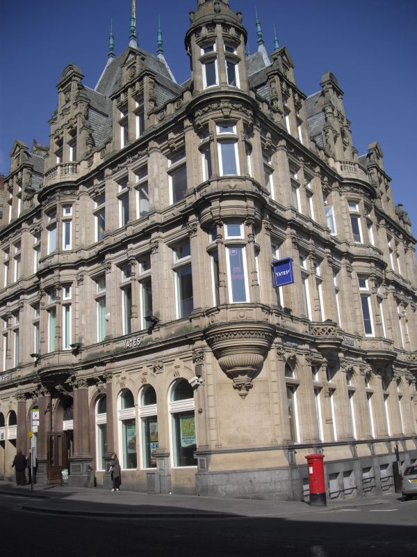
NZ 2464 SE NEWCASTLE UPON TYNE GRAINGER STREET
(east side)
20/261 No. 30
G.V. II
Commercial building. 1884-6 by John Johnstone for the Newcastle and Gateshead
Gas Company. Sandstone ashlar, with slate roofs, in French Renaissance style.
3 storeys and attics, basement on south front to St. John Street. 3 by 3 wide
bays plus an angled corner bay. Arcaded ground floor altered on West front to
provide shop windows. The central bay on either front breaks forward in a 2-
storey rounded oriel with a balustraded parapet before an elaborate 3-stage
pilastered gable backing on to a pavilion roof. The side bays have shallower
square pilastered projections and smaller pedimented 2-stage attic gables... The
corner bay is an oriel, on a heavy rounded and moulded corbel, rising to a dome
with a smaller drum, dome and finial above. Horizontal stability is given by
banded rustication on the narrow wall spaces and by entablatures with panelled
blocking courses at floor levels. 3 or 4 plain windows to each bay.
Listing NGR: NZ2471564065
External links are from the relevant listing authority and, where applicable, Wikidata. Wikidata IDs may be related buildings as well as this specific building. If you want to add or update a link, you will need to do so by editing the Wikidata entry.


Other nearby listed buildings
