Approximate Location Map
Large Map »
Latitude: 53.2753 / 53°16'30"N
Longitude: -1.6555 / 1°39'19"W
OS Eastings: 423072
OS Northings: 375418
OS Grid: SK230754
Mapcode National: GBR JZWK.DM
Mapcode Global: WHCCV.JYX0
Plus Code: 9C5W78GV+3R
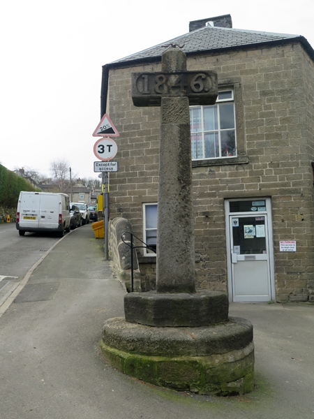
Entry Name: Village Cross
Listing Date: 12 July 1967
Grade: II
Source: Historic England
Source ID: 1356128
English Heritage Legacy ID: 80710
ID on this website: 101356128
Location: Stoney Middleton, Derbyshire Dales, Derbyshire, S32
County: Derbyshire
District: Derbyshire Dales
Civil Parish: Stoney Middleton
Traditional County: Derbyshire
Lieutenancy Area (Ceremonial County): Derbyshire
Church of England Parish: Stoney Middleton St Martin
Church of England Diocese: Derby
Tagged with: High cross
SK 27 NW PARISH OF STONEY MIDDLETON HIGH STREET
4/95 (North Side)
12-7-67 Village Cross
II
Cross. 1846. Stone. Circular rubble plinth. Octagonal stone base with tapering
rectangular pier over, repaired at top. Short arms have inset panel to west
inscribed '1846' in large numbers. Erected to celebrate the repeal of the Corn Laws.
Listing NGR: SK2307275418
External links are from the relevant listing authority and, where applicable, Wikidata. Wikidata IDs may be related buildings as well as this specific building. If you want to add or update a link, you will need to do so by editing the Wikidata entry.


Other nearby listed buildings
