Approximate Location Map
Large Map »
Latitude: 53.4843 / 53°29'3"N
Longitude: -2.8959 / 2°53'45"W
OS Eastings: 340647
OS Northings: 398995
OS Grid: SJ406989
Mapcode National: GBR 8X64.VP
Mapcode Global: WH86W.HP76
Plus Code: 9C5VF4M3+PJ
Entry Name: Sefton Cottage
Listing Date: 20 June 1975
Grade: II
Source: Historic England
Source ID: 1356208
English Heritage Legacy ID: 215178
ID on this website: 101356208
Location: Kirkby, Knowsley, Merseyside, L32
County: Knowsley
Electoral Ward/Division: Whitefield
Parish: Non Civil Parish
Built-Up Area: Kirkby
Traditional County: Lancashire
Lieutenancy Area (Ceremonial County): Merseyside
Church of England Parish: Kirkby St Chad
Church of England Diocese: Liverpool
Tagged with: Cottage
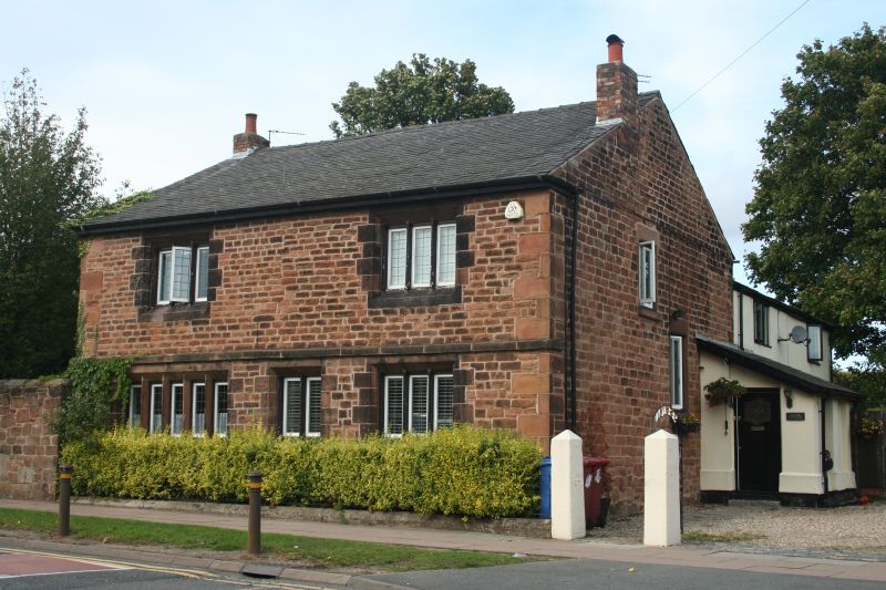
KIRKBY ROW
1.
5090
Sefton Cottage
SJ 49 NW 1/7
II
2.
Now flats. Red sandstone house with ashlar quoins, band, 2 storeys, wood eaves.
Victorian. 3 windows on ground floor and 2 above, of 2, 3 and 4 lights, but
only one 4-light window retains stone mullions. At entrance to new school.
Listing NGR: SJ4064798995
External links are from the relevant listing authority and, where applicable, Wikidata. Wikidata IDs may be related buildings as well as this specific building. If you want to add or update a link, you will need to do so by editing the Wikidata entry.


Other nearby listed buildings
