Approximate Location Map
Large Map »
Latitude: 51.4601 / 51°27'36"N
Longitude: -0.307 / 0°18'25"W
OS Eastings: 517717
OS Northings: 174822
OS Grid: TQ177748
Mapcode National: GBR 75.R9N
Mapcode Global: VHGR2.MKLJ
Plus Code: 9C3XFM6V+36
Entry Name: 19, King Street
Listing Date: 25 June 1983
Grade: II
Source: Historic England
Source ID: 1357720
English Heritage Legacy ID: 205531
ID on this website: 101357720
Location: Richmond upon Thames, London, TW9
County: London
District: Richmond upon Thames
Electoral Ward/Division: South Richmond
Parish: Non Civil Parish
Built-Up Area: Richmond upon Thames
Traditional County: Surrey
Lieutenancy Area (Ceremonial County): Greater London
Church of England Parish: Richmond
Church of England Diocese: Southwark
Tagged with: Building
1.
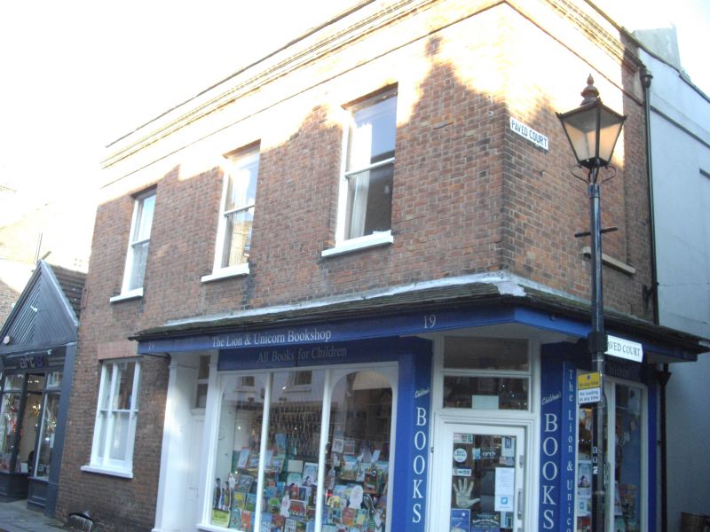
5028 KING STREET
(south side)
No 19
TQ 1774 NE 20A/42 24.12.68
II
2.
Earlier C18, re-fronted C19, shop. Two storeys. Three windows wide to front. One
window return to paved court. Brick parapeted front. Tiled roof with 2 dormers.
C19 shop front with tiled pentice.
Listing NGR: TQ1771874821
External links are from the relevant listing authority and, where applicable, Wikidata. Wikidata IDs may be related buildings as well as this specific building. If you want to add or update a link, you will need to do so by editing the Wikidata entry.


Other nearby listed buildings
