Approximate Location Map
Large Map »
Latitude: 51.5125 / 51°30'45"N
Longitude: -0.0352 / 0°2'6"W
OS Eastings: 536440
OS Northings: 181120
OS Grid: TQ364811
Mapcode National: GBR K4.FS8
Mapcode Global: VHGR1.B7RT
Plus Code: 9C3XGX77+2W
Entry Name: Railway Bridge
Listing Date: 27 September 1973
Grade: II
Source: Historic England
Source ID: 1357806
English Heritage Legacy ID: 205878
ID on this website: 101357806
Location: Limehouse, Tower Hamlets, London, E14
County: London
District: Tower Hamlets
Electoral Ward/Division: Mile End
Parish: Non Civil Parish
Built-Up Area: Tower Hamlets
Traditional County: Middlesex
Lieutenancy Area (Ceremonial County): Greater London
Church of England Parish: St Dunstan Stepney
Church of England Diocese: London
Tagged with: Railway bridge
788/17/908
26-APR-04
STEPNEY
COMMERCIAL ROAD E14
(South side)
Railway Bridge
COMMERCIAL ROAD E1
(South side)
Railway Bridge
GV
II
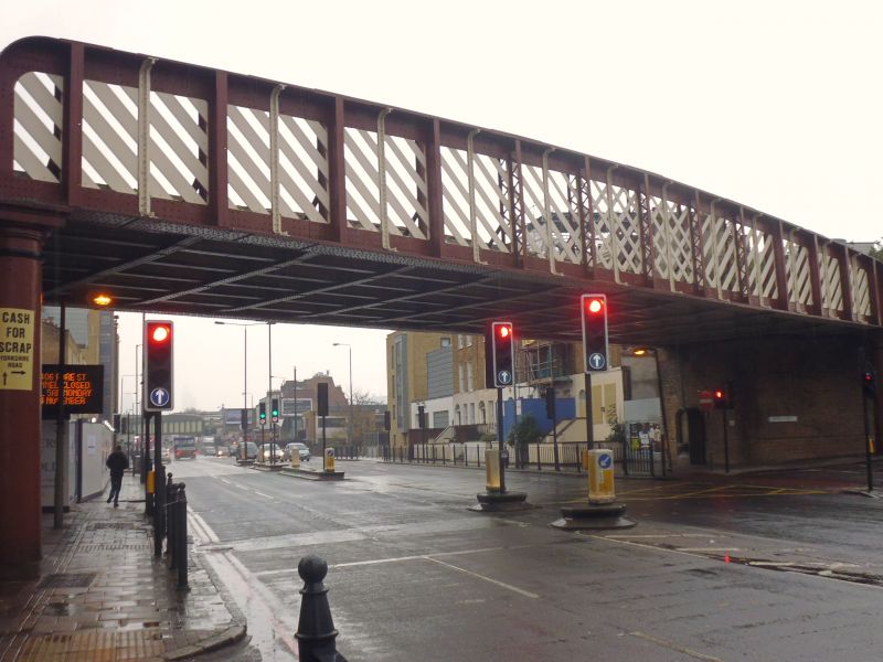
Former railway bridge, now dis-used. 1870s for London and Blackwall Railway Company and its lessee, Great Eastern Railway. Wrought-iron superstructure supported by brick abutments and three cast iron columns.
Superstructure of latticed box girder with flat bolted underside and diagonal tensile members of wrought-iron flat plates. Yellow brick abutments in English bond at each end carry the superstructure, along with pair of additional cast iron column supports to east side. Drinking Fountain (q.v.) attached to northern abutment. The superstructure, abutments, and columns are all structural components of the bridge. The c.1880 viaduct continues to north and south.
HISTORY: The London and Blackwall Railway Company and it lessee, the Great Eastern Railway Company, completed the viaduct that carry the Limehouse Curve in 1880. This link provided a link, allowing goods trains from Millwall and the other London Docks to run directly onto the main-line system of the Great Eastern Railway. The listed bridge is much wider than the present roadway, reflecting the greater width of the Commerical Road it was built to cross. Commercial Road was constructed c.1802-04 as the toll road connecting the East and West India Docks and the City.
Listed as a late-C1870s distinctive railway bridge for the Great Eastern Railway with wrought iron latticed superstructure and additional cast iron columns supports, also having historic interest and strong group value.
Group value with the Grade II London and Blackwall Railway viaduct of 1839-40 (q.v.), the adjacent houses along Commercial Road (q.v.), the Accumulative Tower (q.v.) and the dated 1886 Drinking Fountain attached to the northern abutment (q.v.)
External links are from the relevant listing authority and, where applicable, Wikidata. Wikidata IDs may be related buildings as well as this specific building. If you want to add or update a link, you will need to do so by editing the Wikidata entry.


Other nearby listed buildings
