Approximate Location Map
Large Map »
Latitude: 51.4951 / 51°29'42"N
Longitude: -0.1196 / 0°7'10"W
OS Eastings: 530630
OS Northings: 179022
OS Grid: TQ306790
Mapcode National: GBR KL.97
Mapcode Global: VHGQZ.WP38
Plus Code: 9C3XFVWJ+24
Entry Name: Wall on South Side of Main Courtyard at Lambeth Palace
Listing Date: 27 March 1981
Grade: II
Source: Historic England
Source ID: 1358294
English Heritage Legacy ID: 204401
ID on this website: 101358294
Location: Lambeth, London, SE1
County: London
District: Lambeth
Electoral Ward/Division: Bishop's
Parish: Non Civil Parish
Built-Up Area: Lambeth
Traditional County: Surrey
Lieutenancy Area (Ceremonial County): Greater London
Church of England Parish: North Lambeth
Church of England Diocese: Southwark
Tagged with: Wall
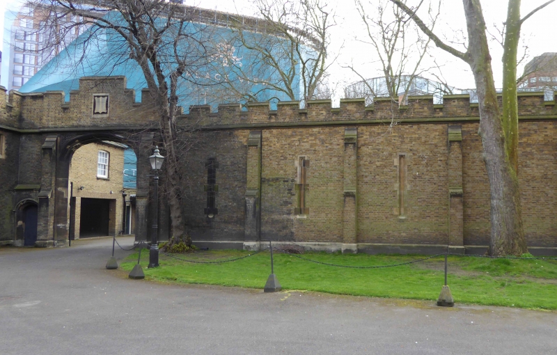
LAMBETH PALACE ROAD SE1
1. (east side)
5023
Wall on south side of
main courtyard at
Lambeth Palace
TQ 3079 2/586
II
2.
Early-mid C19 tall battlemented stock brick wall dividing the Palace grounds from
St Mary's Churchyard. Entrance archway.
Listing NGR: TQ3063079021
External links are from the relevant listing authority and, where applicable, Wikidata. Wikidata IDs may be related buildings as well as this specific building. If you want to add or update a link, you will need to do so by editing the Wikidata entry.


Other nearby listed buildings
