Approximate Location Map
Large Map »
Latitude: 51.3546 / 51°21'16"N
Longitude: 0.1432 / 0°8'35"E
OS Eastings: 549328
OS Northings: 163909
OS Grid: TQ493639
Mapcode National: GBR RB.JRC
Mapcode Global: VHHPC.F6JW
Plus Code: 9F32943V+V7
Entry Name: Forkways
Listing Date: 29 June 1973
Grade: II
Source: Historic England
Source ID: 1359331
English Heritage Legacy ID: 358503
ID on this website: 101359331
Location: Maypole, Bromley, London, BR6
County: London
District: Bromley
Electoral Ward/Division: Chelsfield and Pratts Bottom
Parish: Non Civil Parish
Traditional County: Kent
Lieutenancy Area (Ceremonial County): Greater London
Church of England Parish: Chelsfield St Martin of Tours
Church of England Diocese: Rochester
Tagged with: Building
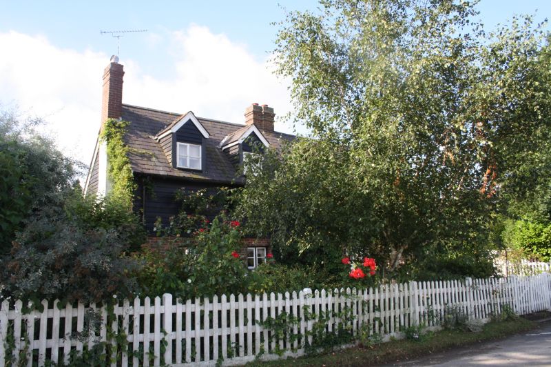
1. JUBILEE ROAD CHELSFIELD
4407 (South Side)
Forkways
TQ 46 SE 10/282
II
2.
A probable timber-framed house refaced in the Cl9. 2 storeys, ground floor brick.
1st floor weatherboarded. Steeply pitched slate roof which ends abruptly at
the left side with brick chimneystack. Hipped on right side. Cl9 casements.
Hipped weather porch.
Listing NGR: TQ4932863909
External links are from the relevant listing authority and, where applicable, Wikidata. Wikidata IDs may be related buildings as well as this specific building. If you want to add or update a link, you will need to do so by editing the Wikidata entry.


Other nearby listed buildings
