Approximate Location Map
Large Map »
Latitude: 52.2015 / 52°12'5"N
Longitude: -2.2252 / 2°13'30"W
OS Eastings: 384708
OS Northings: 255939
OS Grid: SO847559
Mapcode National: GBR 1FY.VNB
Mapcode Global: VH92M.DX0Q
Plus Code: 9C4V6Q2F+HW
Entry Name: 12, Barbourne Road
Listing Date: 22 May 1954
Last Amended: 27 June 2001
Grade: II
Source: Historic England
Source ID: 1359554
English Heritage Legacy ID: 488494
ID on this website: 101359554
Location: Britannia Square, Worcester, Worcestershire, WR1
County: Worcestershire
District: Worcester
Electoral Ward/Division: Arboretum
Parish: Non Civil Parish
Built-Up Area: Worcester
Traditional County: Worcestershire
Lieutenancy Area (Ceremonial County): Worcestershire
Church of England Parish: Worcester St George with St Mary Magdalene
Church of England Diocese: Worcester
Tagged with: Building
WORCESTER
SO8455NE BARBOURNE ROAD
620-1/8/28 (East side)
22/5/54 No.12
(Formerly Listed as:
BARBOURNE ROAD
(East side)
Nos.12 AND 14)
II
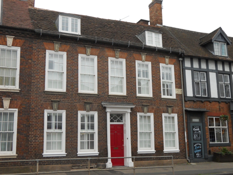
House, part of terrace. c1770 with later additions and
alterations. Red brick with hand-made plain clay-tiles.
Gable-end stacks to rear roof slope. Lead roof and sides to
box dormers. Timber doorcase. Stone sills and keystones to
windows. Simple rendered plinth. Cast-iron boot scraper.
Double-depth plan with central entrance and hallway.
Symmetrical facade. 2-storeys with cellars and attics. 5
first-floor windows. Dentilled eaves. All sashes are 6/6 with
flush, exposed boxes; flat gauged-brick arches with projecting
moulded and capped keystones; sills have projecting moulded
top-face. 2 full-dormers with 6-pane paired casements.
Doric-style doorcase with engaged part-fluted columns on
plinths, frieze and cornice; 5 panel door, upper panels raised
and fielded, bottom panel flush-beaded with inscribed
elliptical motif; panelled reveals; overlight with
lozenge-and-square glazing bar pattern. Floor-mounted boot
scraper to right of door. Similar to Nos 14 and 16 (qv)
Barbourne Road.
INTERIOR: not inspected.
(Buildings of England: Pevsner N: Worcestershire:
Harmondsworth: 1968-1985: 334).
External links are from the relevant listing authority and, where applicable, Wikidata. Wikidata IDs may be related buildings as well as this specific building. If you want to add or update a link, you will need to do so by editing the Wikidata entry.


Other nearby listed buildings
