Approximate Location Map
Large Map »
Latitude: 52.5884 / 52°35'18"N
Longitude: -0.7203 / 0°43'13"W
OS Eastings: 486791
OS Northings: 299727
OS Grid: SP867997
Mapcode National: GBR CSK.QPJ
Mapcode Global: WHFL1.X65G
Plus Code: 9C4XH7QH+9V
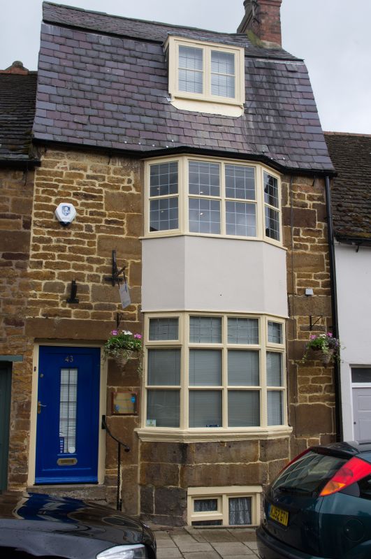
Entry Name: 43, High Street East
Listing Date: 15 October 1984
Grade: II
Source: Historic England
Source ID: 1361812
English Heritage Legacy ID: 186766
ID on this website: 101361812
Location: Uppingham, Rutland, LE15
County: Rutland
Civil Parish: Uppingham
Built-Up Area: Uppingham
Traditional County: Rutland
Lieutenancy Area (Ceremonial County): Rutland
Church of England Parish: Uppingham St Peter and St Paul
Church of England Diocese: Peterborough
Tagged with: Building
SP 8699-8799 UPPINGHAM HIGH STREET EAST
4/29 (north side)
No 43
GV
II
House. Late C18. Coursed rubble with brick gable ends, Mansard Welsh slate roof and
brick east end stack. Two storeys and attic. Door to left, and 2-storey canted bay
window to right. Flat-roofed dormer. Included for group value.
Listing NGR: SP8679199727
External links are from the relevant listing authority and, where applicable, Wikidata. Wikidata IDs may be related buildings as well as this specific building. If you want to add or update a link, you will need to do so by editing the Wikidata entry.


Other nearby listed buildings
