Approximate Location Map
Large Map »
Latitude: 51.2731 / 51°16'23"N
Longitude: 0.3198 / 0°19'11"E
OS Eastings: 561910
OS Northings: 155216
OS Grid: TQ619552
Mapcode National: GBR NPM.3NF
Mapcode Global: VHHPV.H8DD
Plus Code: 9F3278F9+6W
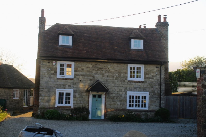
Entry Name: Winfield Farmhouse
Listing Date: 31 July 1979
Grade: II
Source: Historic England
Source ID: 1362022
English Heritage Legacy ID: 357343
ID on this website: 101362022
Location: Crouch, Tonbridge and Malling, Kent, TN15
County: Kent
District: Tonbridge and Malling
Civil Parish: Plaxtol
Traditional County: Kent
Lieutenancy Area (Ceremonial County): Kent
Church of England Parish: Platt St Mary the Virgin
Church of England Diocese: Rochester
Tagged with: Farmhouse
TQ 65 NW PLAXTOL LONG MILL LANE
2/31 (west side)
31.7.79 Winfield Farmhouse
GV
II
Farmhouse. Mid-late C18. Coursed dressed stone. Moulded eaves to plain
tiled roof, half-hipped to left, with 2 hipped dormers and projecting end
stacks. Two storeys; 2 windows, C19 casements. Central half-glazed and
pantiled door with flat projecting hood supported on carved brackets.
Listing NGR: TQ6191055216
External links are from the relevant listing authority and, where applicable, Wikidata. Wikidata IDs may be related buildings as well as this specific building. If you want to add or update a link, you will need to do so by editing the Wikidata entry.


Other nearby listed buildings
