Approximate Location Map
Large Map »
Latitude: 53.8292 / 53°49'45"N
Longitude: -2.9851 / 2°59'6"W
OS Eastings: 335260
OS Northings: 437440
OS Grid: SD352374
Mapcode National: GBR 7SL5.J2
Mapcode Global: WH859.30ST
Plus Code: 9C5VR2H7+MX
Entry Name: Fox's Farmhouse
Listing Date: 16 August 1983
Grade: II
Source: Historic England
Source ID: 1362190
English Heritage Legacy ID: 184780
ID on this website: 101362190
Location: Hardhorn Village, Wyre, Lancashire, FY6
County: Lancashire
District: Wyre
Electoral Ward/Division: Hardhorn with High Cross
Parish: Non Civil Parish
Built-Up Area: Poulton-le-Fylde
Traditional County: Lancashire
Lieutenancy Area (Ceremonial County): Lancashire
Church of England Parish: Poulton-le-Fylde St Chad
Church of England Diocese: Blackburn
Tagged with: Farmhouse
SD 33 NE POULTON-LE-FYLDE FAIRFIELD ROAD
Hardhorn
4/3
Fox's Farmhouse
II
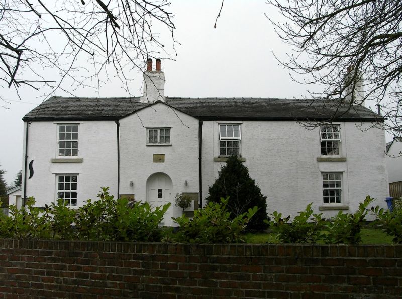
Farmhouse, probably early C18 with alterations. Rendered brick with stone
quoins to ground floor, roof of slates except 4 courses stone slates on
outshut to rear. Baffle-entry plan of 3 bays with outshut; axial chimney
stack between 1st and 2nd bays, gable chimney stack at right end. 2-storey
gabled porch between 1st and 2nd bays, with semicircular arched opening and
2-light sliding sash window above, internal benches and unglazed peepholes.
6 identical sashed windows with glazing bars and stone sills, one on each
floor in each bay; remains of string course below top of ground floor
window in 1st bay. Interior: wide hearths with large bressumer beams in 1st bay
(original kitchen) and in housepart; dog-leg staircase in outshut from parlour,
quarter-turn staircase in kitchen; doors with shouldered panels. (1721
datestone is no longer visible).
Listing NGR: SD3526037440
External links are from the relevant listing authority and, where applicable, Wikidata. Wikidata IDs may be related buildings as well as this specific building. If you want to add or update a link, you will need to do so by editing the Wikidata entry.


Other nearby listed buildings
