Approximate Location Map
Large Map »
Latitude: 54.1097 / 54°6'34"N
Longitude: -2.6359 / 2°38'9"W
OS Eastings: 358521
OS Northings: 468387
OS Grid: SD585683
Mapcode National: GBR BN1X.4K
Mapcode Global: WH951.HY0T
Plus Code: 9C6V4957+VJ
Entry Name: Hornby Bridge
Listing Date: 4 October 1967
Grade: II
Source: Historic England
Source ID: 1362571
English Heritage Legacy ID: 182414
ID on this website: 101362571
Location: Hornby, Lancaster, Lancashire, LA2
County: Lancashire
District: Lancaster
Civil Parish: Hornby-with-Farleton
Traditional County: Lancashire
Lieutenancy Area (Ceremonial County): Lancashire
Church of England Parish: Hornby with Claughton
Church of England Diocese: Blackburn
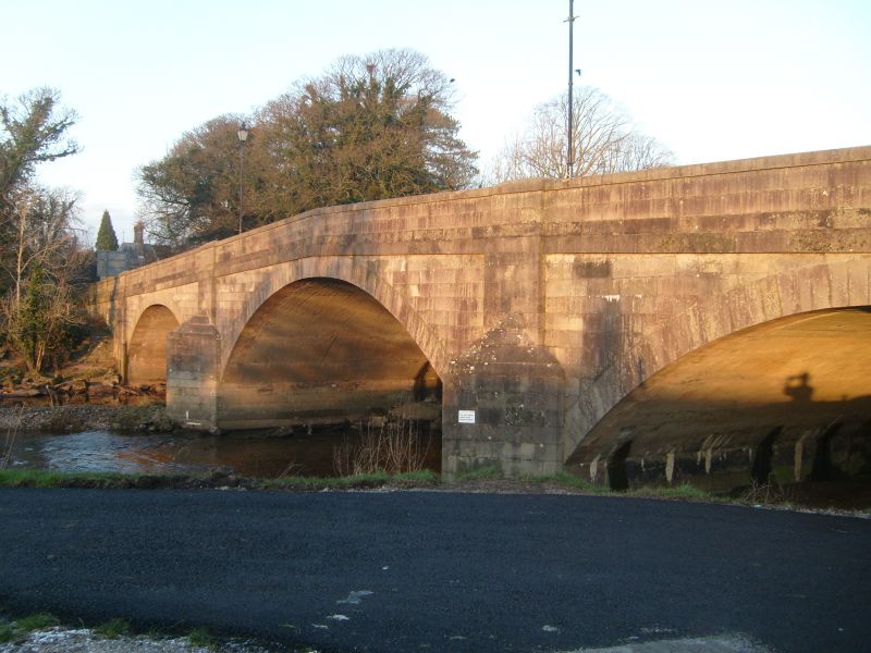
HORNBY-WITH-FARLETON MAIN STREET
SD 56 NE
7/118 Hornby Bridge
4-10-1967
GV II
Bridge, 1769 (Village Guide), widened on west side during Second World
War. Sandstone ashlar. 3 segmental arches with triangular cutwaters, and
band below solid parapet with coping. Masons' marks visible on soffits of
arches.
Listing NGR: SD5852468392
External links are from the relevant listing authority and, where applicable, Wikidata. Wikidata IDs may be related buildings as well as this specific building. If you want to add or update a link, you will need to do so by editing the Wikidata entry.


Other nearby listed buildings
