Approximate Location Map
Large Map »
Latitude: 52.2425 / 52°14'33"N
Longitude: 0.7124 / 0°42'44"E
OS Eastings: 585281
OS Northings: 263946
OS Grid: TL852639
Mapcode National: GBR QF0.6YK
Mapcode Global: VHKD4.9WGS
Plus Code: 9F426PV6+2W
Entry Name: 24, 25 and 26, Guildhall Street
Listing Date: 12 July 1972
Grade: II
Source: Historic England
Source ID: 1363727
English Heritage Legacy ID: 466845
ID on this website: 101363727
Location: Bury St Edmunds, West Suffolk, IP33
County: Suffolk
District: West Suffolk
Civil Parish: Bury St Edmunds
Built-Up Area: Bury St Edmunds
Traditional County: Suffolk
Lieutenancy Area (Ceremonial County): Suffolk
Church of England Parish: Bury St Edmunds St Mary
Church of England Diocese: St.Edmundsbury and Ipswich
Tagged with: Building
BURY ST EDMUNDS
TL8563NW GUILDHALL STREET
639-1/15/372 (East side)
12/07/72 Nos.24, 25 AND 26
GV II
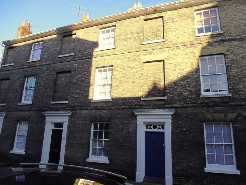
A row of 3 houses. Early C19. White brick; slate roofs with a
paired bracketed eaves soffit.
EXTERIOR: 3 storeys and cellars. 6 window range: 12-pane
sashes to the ground and 1st storeys, 9-pane to the 2nd
storey, all with plain reveals, flat gauged arches and stone
sills. Alternate window openings are blocked. Raised brick
bands run between the storeys. 6-panel doors with rectangular
fanlights.
No.26 with the original glazing bars, the others blank,
surrounds with plain pilasters and dentilled cornices. Rear
elevations in flint and red brick. 12-pane sash windows with
segmental heads to frames and surrounds in shallow reveals.
INTERIOR: cellar to No.24 has walls of flint, brick and stone
blocks with a reused ceiling beam. No earlier features within
the house. Early C19 corner stair with closed strings, stick
balusters, ramped handrails and column newels. Internal window
shutters with sunk panels. Reeded fireplace surround. One
ornate cast-iron raised grate on the 1st storey. Early C19
features said to remain also in No.26.
Listing NGR: TL8528163946
External links are from the relevant listing authority and, where applicable, Wikidata. Wikidata IDs may be related buildings as well as this specific building. If you want to add or update a link, you will need to do so by editing the Wikidata entry.


Other nearby listed buildings
