Approximate Location Map
Large Map »
Latitude: 51.5467 / 51°32'48"N
Longitude: -2.2315 / 2°13'53"W
OS Eastings: 384046
OS Northings: 183117
OS Grid: ST840831
Mapcode National: GBR 1PW.SSC
Mapcode Global: VH95X.8DP4
Plus Code: 9C3VGQW9+MC
Entry Name: Manor Farmhouse
Listing Date: 29 February 1988
Grade: II
Source: Historic England
Source ID: 1363842
English Heritage Legacy ID: 316013
ID on this website: 101363842
Location: Alderton, Wiltshire, SN14
County: Wiltshire
Civil Parish: Luckington
Traditional County: Wiltshire
Lieutenancy Area (Ceremonial County): Wiltshire
Church of England Parish: Sherston Magna, Easton Grey, Luckington and Alderton
Church of England Diocese: Bristol
Tagged with: Farmhouse
LUCKINGTON ALDERTON
ST 88 SW (west side)
2/200 Manor Farmhouse
GV II
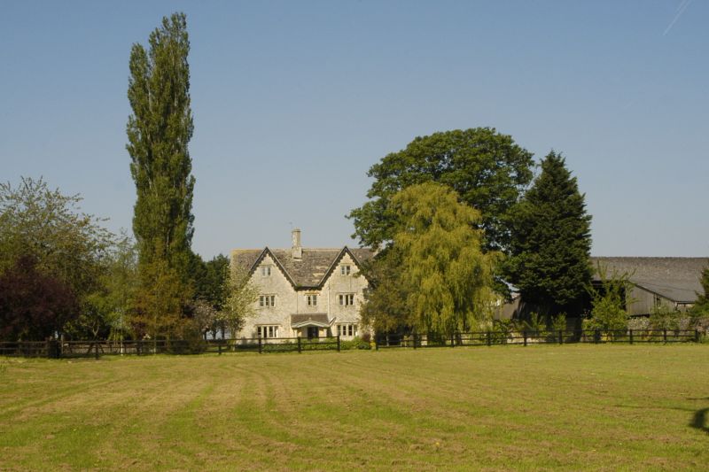
Farmhouse, dated 1676, extended in mid C19, rubble stone with
imitation stone slate roof and two diagonally-shafted ashlar ridge
stacks. 2½ storeys, originally with symmetrical double-gabled 3-
window front of ovolo-moulded mullion windows and hoodmoulds but
with matching third gable added in mid C19. Original range has
attic 2-light, first floor 3-light each side and 2-light centre,
and ground floor 4-light with king-mullion each side of door in
flush moulded doorcase. c1830-40 added porch by J. Thomson, lean-
to but with shallow open pedimental gable and ball finial. Ashlar
chamfered outer piers with curious swollen caps. C19 barge boards.
Added gable to right has similar attic and first floor windows and
barge boards. Rear has four gables, stepped forward from right to
left, the left gable C19 the right gable obscured by added rear
wing. Manor Farm is illustrated in J. Thomson's unpublished 1845
History of the Church and Village of Alderton 77, with barge boards
and porch but without added gable.
Listing NGR: ST8404683117
External links are from the relevant listing authority and, where applicable, Wikidata. Wikidata IDs may be related buildings as well as this specific building. If you want to add or update a link, you will need to do so by editing the Wikidata entry.


Other nearby listed buildings
