Approximate Location Map
Large Map »
Latitude: 51.4221 / 51°25'19"N
Longitude: -1.7275 / 1°43'38"W
OS Eastings: 419044
OS Northings: 169262
OS Grid: SU190692
Mapcode National: GBR 4X2.VDZ
Mapcode Global: VHC1P.0JL6
Plus Code: 9C3WC7CF+R2
Entry Name: 15 and 16, the Green
Listing Date: 21 October 1974
Grade: II
Source: Historic England
Source ID: 1365367
English Heritage Legacy ID: 310300
ID on this website: 101365367
Location: Marlborough, Wiltshire, SN8
County: Wiltshire
Civil Parish: Marlborough
Built-Up Area: Marlborough
Traditional County: Wiltshire
Lieutenancy Area (Ceremonial County): Wiltshire
Tagged with: Building
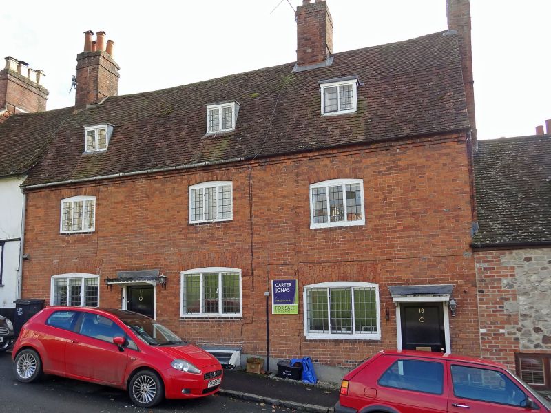
THE GREEN
1.
5407
(South Side)
Nos 15 and 16
SU 1969 1/165
II GV
2.
Cl8. 2 storeys and attic. Red brick. Mansard old tile roof. 3 small dormer
casements. Three 3-light leaded casements and 2 doors with sma11 flat hoods.
This house adjoins No 1 Barn Street, the end wall of the latter facing the Green.
Nos 8 to 16 (consec) form a group.
Listing NGR: SU1905069263
External links are from the relevant listing authority and, where applicable, Wikidata. Wikidata IDs may be related buildings as well as this specific building. If you want to add or update a link, you will need to do so by editing the Wikidata entry.


Other nearby listed buildings
