Approximate Location Map
Large Map »
Latitude: 52.2502 / 52°15'0"N
Longitude: 0.7162 / 0°42'58"E
OS Eastings: 585510
OS Northings: 264812
OS Grid: TL855648
Mapcode National: GBR QDT.V74
Mapcode Global: VHKD4.CPGV
Plus Code: 9F427P28+3F
Entry Name: 96 and 96A, Northgate Street
Listing Date: 13 March 1987
Last Amended: 30 October 1997
Grade: II
Source: Historic England
Source ID: 1365769
English Heritage Legacy ID: 467025
ID on this website: 101365769
Location: Bury St Edmunds, West Suffolk, IP33
County: Suffolk
District: West Suffolk
Civil Parish: Bury St Edmunds
Built-Up Area: Bury St Edmunds
Traditional County: Suffolk
Lieutenancy Area (Ceremonial County): Suffolk
Church of England Parish: Bury St Edmunds St John the Evangelist
Church of England Diocese: St.Edmundsbury and Ipswich
Tagged with: Building
BURY ST EDMUNDS
TL8564NE NORTHGATE STREET
639-1/4/496 (East side)
13/03/87 Nos.96 AND 96A
(Formerly Listed as:
NORTHGATE STREET
(East side)
No.96A)
II
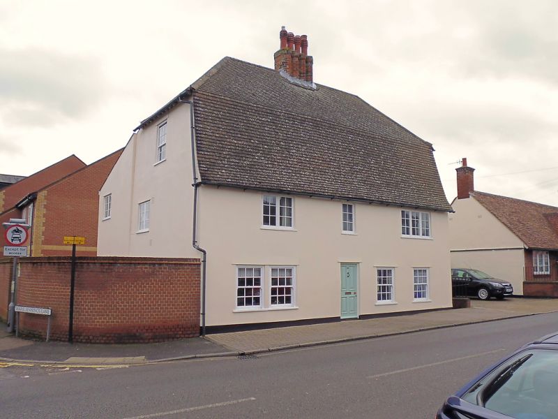
House, now used as doctors' surgeries with a flat above.
c1600; altered in the C18 and extensively restored in the late
C20. Timber-framed with roughcast render; concrete plaintiled
roof, raised in C18, mansard, half hipped. Basically, a 2-cell
lobby entrance plan with internal chimney-stack: 4 attached
hexagonal shafts with corbelled heads, partly obscured by the
later roof-raising.
EXTERIOR: 2 storeys and attics. Mixed random fenestration.
Most windows are now C20 replacements: small-paned casements
to the 1st storey and 3 12-pane sash windows to the ground
storey; all windows with slight reveals. One half-glazed C20
door. At the rear, a 2-storey lean-to extension, basically in
red brick. The brick was formerly painted and the back wall
had areas of older random brick with a mixture of Abbey stone,
all covered since restoration by render.
INTERIOR: the main range is in 3 bays, including a narrow
chimney-bay, with some plain framing exposed: chamfered main
beams on the ground storey and unchamfered joists set flat.
The stair to the upper floors has been resited in a new porch
extension on the south side. On the 1st storey, studding and
main posts with long jowls along the front wall with evidence
of fire damage.
Upper ceilings with widely-spaced joists set on edge. The C18
mansard roof has bisected rafters and straight braces. Within
the attic the chimney-stack is of Tudor brick.
Listing NGR: TL8551064812
External links are from the relevant listing authority and, where applicable, Wikidata. Wikidata IDs may be related buildings as well as this specific building. If you want to add or update a link, you will need to do so by editing the Wikidata entry.


Other nearby listed buildings
