Approximate Location Map
Large Map »
Latitude: 52.9278 / 52°55'39"N
Longitude: -3.057 / 3°3'25"W
OS Eastings: 329040
OS Northings: 337229
OS Grid: SJ290372
Mapcode National: GBR 73.MMWH
Mapcode Global: WH89J.0NKW
Plus Code: 9C4RWWHV+45
Entry Name: Chirk Bridge
Listing Date: 2 September 1987
Grade: II
Source: Historic England
Source ID: 1367346
English Heritage Legacy ID: 255716
ID on this website: 101367346
Location: Chirk Bank, Shropshire, LL14
County: Shropshire
Civil Parish: St. Martin's
Traditional County: Shropshire
Lieutenancy Area (Ceremonial County): Shropshire
Church of England Parish: Weston Rhyn St John
Church of England Diocese: Lichfield
Tagged with: Bridge
ST. MARTIN'S C.P.
SJ 23 NE
1/4
A5
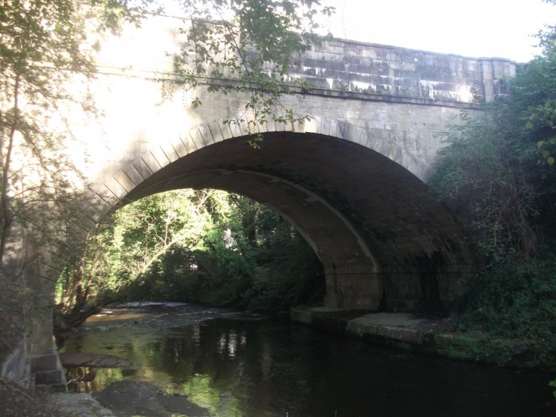
Chirk Bridge
II
Bridge. Circa 1798 by Thomas Telford with later repairs and alterations. Yellow sandstone ashlar. Single segmental arch, projecting keystone and rusticated voussoirs struck through to soffit. Flat string course, pilasters, coped parapet and rectangular corner piers. The contract for construction was awarded to John Simpson of Shrewsbury for which he was paid £1,093. Minor repairs were carried out by Thomas Stanton and Edward Haycock in 1831 and 1844 respectively. The bridge was widened in reinforced concrete during the 1920s but was faced with the original masonry. Spans the River Ceiriog.
This entry was subject to a Minor Amendment on 25 October 2016.
External links are from the relevant listing authority and, where applicable, Wikidata. Wikidata IDs may be related buildings as well as this specific building. If you want to add or update a link, you will need to do so by editing the Wikidata entry.


Other nearby listed buildings
