Approximate Location Map
Large Map »
Latitude: 51.5221 / 51°31'19"N
Longitude: -1.1388 / 1°8'19"W
OS Eastings: 459846
OS Northings: 180710
OS Grid: SU598807
Mapcode National: GBR 920.DX4
Mapcode Global: VHCZ2.60TG
Plus Code: 9C3WGVC6+VF
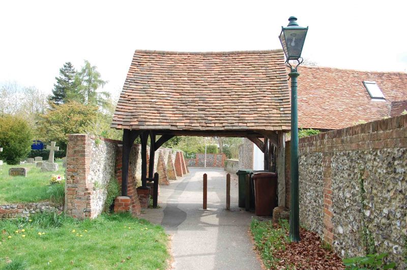
Entry Name: Lychgate Approximately 75 Metres East of Church of St Thomas of Canterbury
Listing Date: 16 August 1985
Grade: II
Source: Historic England
Source ID: 1368959
English Heritage Legacy ID: 247283
ID on this website: 101368959
Location: Goring, South Oxfordshire, RG8
County: Oxfordshire
District: South Oxfordshire
Civil Parish: Goring-on-Thames
Built-Up Area: Goring
Traditional County: Oxfordshire
Lieutenancy Area (Ceremonial County): Oxfordshire
Church of England Parish: Goring
Church of England Diocese: Oxford
Tagged with: Lychgate
GORING MANOR ROAD
SU5980 (West side)
Goring-on-Thames
11/66 Lychgate approx. 75m. E of
Church of St. Thomas of
Canterbury
GV II
Lychgate. C17. Timber framing; plain tile roof. Queen past roof with windbraces
Listing NGR: SU5984780708
External links are from the relevant listing authority and, where applicable, Wikidata. Wikidata IDs may be related buildings as well as this specific building. If you want to add or update a link, you will need to do so by editing the Wikidata entry.


Other nearby listed buildings
