Approximate Location Map
Large Map »
Latitude: 51.5755 / 51°34'31"N
Longitude: -0.9783 / 0°58'42"W
OS Eastings: 470896
OS Northings: 186783
OS Grid: SU708867
Mapcode National: GBR B2Y.5H7
Mapcode Global: VHDW7.0N4M
Plus Code: 9C3XH2GC+5M
Entry Name: Granary Approximately 10 Metres North of Peebles Farmhouse
Listing Date: 13 February 1985
Grade: II
Source: Historic England
Source ID: 1369308
English Heritage Legacy ID: 247112
ID on this website: 101369308
Location: Crocker End, South Oxfordshire, RG9
County: Oxfordshire
District: South Oxfordshire
Civil Parish: Nettlebed
Traditional County: Oxfordshire
Lieutenancy Area (Ceremonial County): Oxfordshire
Church of England Parish: Nettlebed with Highmoor
Church of England Diocese: Oxford
Tagged with: Granary
NETTLEBED CROCKER END
SU7086
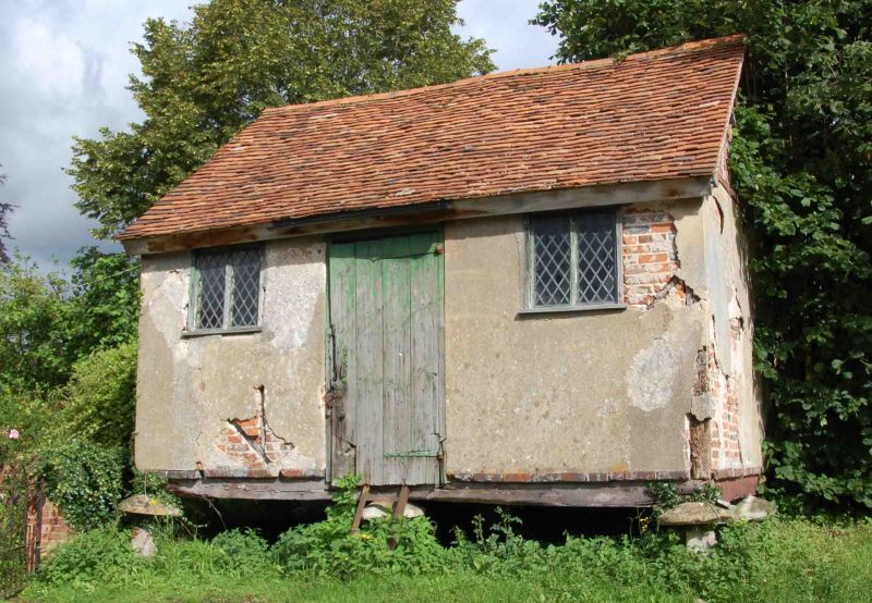
13/90 Granary approx. 10 metres
north of Peebles Farmhouse
GV II
Granary. C18. Staddle stones; timber framing; brick infill, rendered;
gabled tile roof. Plank door.
Listing NGR: SU7089686783
External links are from the relevant listing authority and, where applicable, Wikidata. Wikidata IDs may be related buildings as well as this specific building. If you want to add or update a link, you will need to do so by editing the Wikidata entry.


Other nearby listed buildings
