Approximate Location Map
Large Map »
Latitude: 52.235 / 52°14'5"N
Longitude: -0.8974 / 0°53'50"W
OS Eastings: 475394
OS Northings: 260215
OS Grid: SP753602
Mapcode National: GBR BW8.V85
Mapcode Global: VHDS5.D3F0
Plus Code: 9C4X64M3+X2
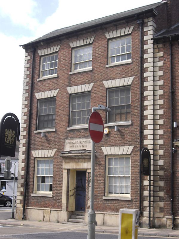
Entry Name: School House
Listing Date: 19 January 1952
Grade: II
Source: Historic England
Source ID: 1372170
English Heritage Legacy ID: 231968
ID on this website: 101372170
Location: Northampton, West Northamptonshire, NN1
County: West Northamptonshire
Electoral Ward/Division: Castle
Parish: Northampton
Built-Up Area: Northampton
Traditional County: Northamptonshire
Lieutenancy Area (Ceremonial County): Northamptonshire
Church of England Parish: Northampton All Saints with St Katherine
Church of England Diocese: Peterborough
Tagged with: House
BRIDGE STREET
5327
(West Side)
No 60
(School House)
SP 756O SW 3/248 19.1.52.
II GV
2.
2811. Brick, stone dressings. 3 storeys. Welsh slated roof. Quotas. 3 sash
windows, glazing bars, steps up to tall central doorway under plaque.
Nos 56 to 60 (even), 60a & 60b form a group.
Listing NGR: SP7539460215
External links are from the relevant listing authority and, where applicable, Wikidata. Wikidata IDs may be related buildings as well as this specific building. If you want to add or update a link, you will need to do so by editing the Wikidata entry.


Other nearby listed buildings
