Approximate Location Map
Large Map »
Latitude: 51.45 / 51°27'0"N
Longitude: -2.6065 / 2°36'23"W
OS Eastings: 357950
OS Northings: 172512
OS Grid: ST579725
Mapcode National: GBR C5M.H1
Mapcode Global: VH88M.RTX8
Plus Code: 9C3VF92V+2C
Entry Name: Gateway and Boundary Wall to East and West Sides of Road
Listing Date: 5 November 1985
Last Amended: 30 December 1994
Grade: II
Source: Historic England
Source ID: 1372296
English Heritage Legacy ID: 379595
ID on this website: 101372296
Location: Canon's Marsh, Bristol, BS8
County: City of Bristol
Electoral Ward/Division: Hotwells and Harbourside
Parish: Non Civil Parish
Built-Up Area: Bristol
Traditional County: Gloucestershire
Lieutenancy Area (Ceremonial County): Bristol
Church of England Parish: Clifton Holy Trinity with St Andrew the Less and St Peter
Church of England Diocese: Bristol
Tagged with: Gate
BRISTOL
ST5772 GASFERRY ROAD, Canon's Marsh
901-1/41/500 (West side)
05/11/85 Gateway and boundary wall to east
and west sides of road
(Formerly Listed as:
GASFERRY ROAD (NORTH)
Gateway and boundary wall fronting
west side of Gasferry Road)
(Formerly Listed as:
GASFERRY ROAD (SOUTH)
Boundary wall fronting east side of
Gasferry Road)
GV II
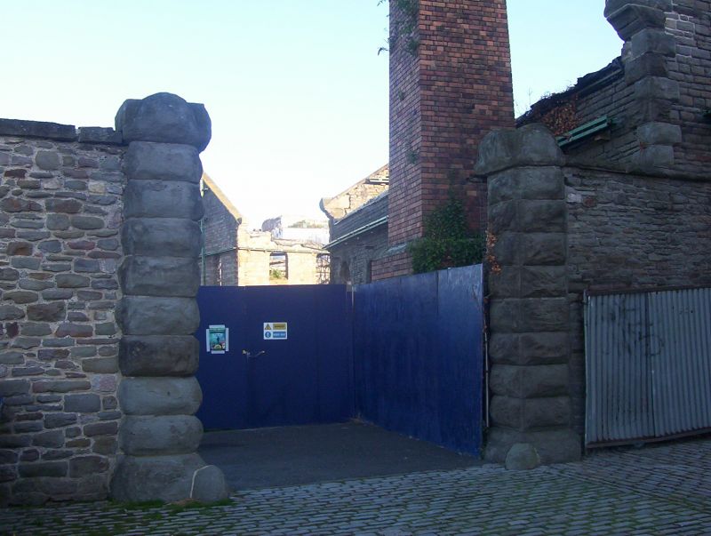
Gateway and boundary wall. c1840. For Bristol and Clifton Oil
Gas Company. Squared coursed Pennant wall and rock-faced
jambs. Gate piers with gableted caps, and curved boundary wall
with brick coping extends approx 100m to W side, and 150m to E
side as far as the former Gas Company offices (qv). Street
with granite setts, iron kerbs and flagged footways. Part of
the extension to the Bristol and Clifton Oil Gas Company's
site, and a most evocative survival of industrial Victorian
urban fabric.
Listing NGR: ST5795072512
External links are from the relevant listing authority and, where applicable, Wikidata. Wikidata IDs may be related buildings as well as this specific building. If you want to add or update a link, you will need to do so by editing the Wikidata entry.


Other nearby listed buildings
