Approximate Location Map
Large Map »
Latitude: 52.3862 / 52°23'10"N
Longitude: -0.6445 / 0°38'40"W
OS Eastings: 492349
OS Northings: 277331
OS Grid: SP923773
Mapcode National: GBR DXH.CWB
Mapcode Global: VHFNZ.S941
Plus Code: 9C4X99P4+F5
Entry Name: The Dairy Farmhouse
Listing Date: 11 August 1976
Grade: II
Source: Historic England
Source ID: 1372394
English Heritage Legacy ID: 231026
ID on this website: 101372394
Location: Cranford St Andrew, North Northamptonshire, NN14
County: North Northamptonshire
Civil Parish: Cranford
Traditional County: Northamptonshire
Lieutenancy Area (Ceremonial County): Northamptonshire
Church of England Parish: Cranford St John the Baptist
Church of England Diocese: Peterborough
Tagged with: Farmhouse Thatched farmhouse
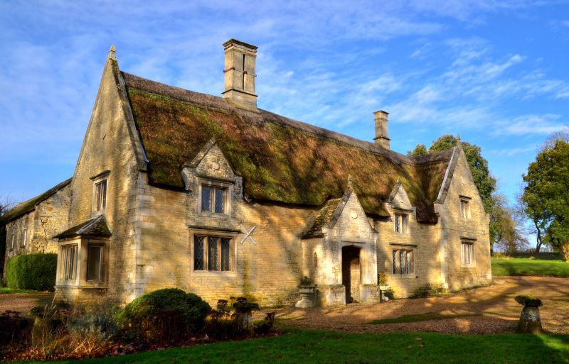
CRANFORD
SP9277 ST.ANDREW'S LANE, Cranford St.Andrew
1337-0/18/300 (South side)
11/08/76 The Dairy Farmhouse
GV II
Farmhouse. Probably C17 altered C19. Coursed limestone rubble
with ashlar dressings, thatched roof with coped gables,
kneelers and finials, and moulded stone ridge stacks. One
storey and attic. Main block and gabled cross-wing. Main block
has central gabled porch with Tudor-arched entrance and C19
door with Gothick tracery and mask flanked by leaves. A
3-light mullioned window with cornice to either side and,
above, 2 2-light gabled half-dormers with mullioned windows
and cornices and shields over. Cross- wing has a 3-light
mullioned window to the ground floor, a 2-light window above
and a shield in the gable. Left gable end has canted bay to
ground floor and a 2-light window above and a shield in the
gable. Left gable end has canted bay to ground floor and a
2-light mullioned window above. Shield in gable. Glazing
mostly diamond lattice. Interior not inspected.
Listing NGR: SP9234977331
External links are from the relevant listing authority and, where applicable, Wikidata. Wikidata IDs may be related buildings as well as this specific building. If you want to add or update a link, you will need to do so by editing the Wikidata entry.


Other nearby listed buildings
