Approximate Location Map
Large Map »
Latitude: 52.63 / 52°37'47"N
Longitude: 1.2914 / 1°17'28"E
OS Eastings: 622840
OS Northings: 308664
OS Grid: TG228086
Mapcode National: GBR W8N.ZY
Mapcode Global: WHMTM.T544
Plus Code: 9F43J7HR+XH
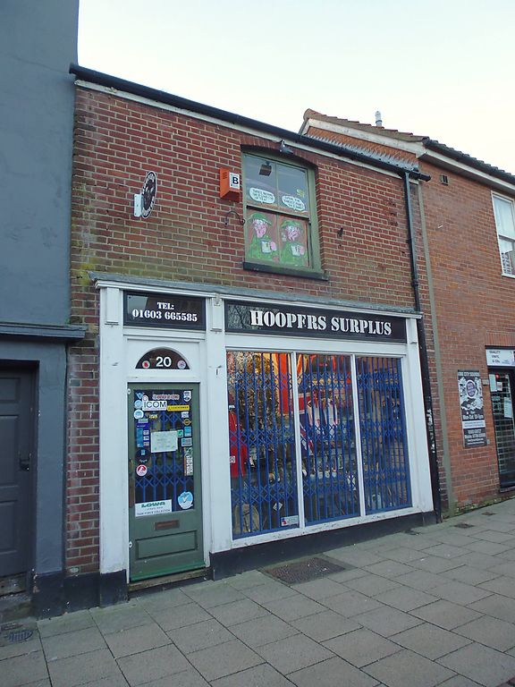
Entry Name: 20, Pottergate
Listing Date: 5 June 1972
Last Amended: 8 April 1986
Grade: II
Source: Historic England
Source ID: 1372462
English Heritage Legacy ID: 229403
ID on this website: 101372462
Location: Norwich, Norfolk, NR2
County: Norfolk
District: Norwich
Electoral Ward/Division: Mancroft
Parish: Non Civil Parish
Built-Up Area: Norwich
Traditional County: Norfolk
Lieutenancy Area (Ceremonial County): Norfolk
Church of England Parish: Norwich St Giles
Church of England Diocese: Norwich
Tagged with: Building
TG 2208 NE POTTERGATE
(south side)
15/632
5.6.72. No. 20 (formerly
listed as Nos. 18
and 20)
GV II
Shop. Late C19. Red brick and Roman pantile roof. 2 storeys. Single
bay. C20 shopfront with left-side door. Sash window at first floor with
segmental arch. Fascia cornice.
Listing NGR: TG2284008664
External links are from the relevant listing authority and, where applicable, Wikidata. Wikidata IDs may be related buildings as well as this specific building. If you want to add or update a link, you will need to do so by editing the Wikidata entry.


Other nearby listed buildings
