Approximate Location Map
Large Map »
Latitude: 53.1988 / 53°11'55"N
Longitude: -2.8737 / 2°52'25"W
OS Eastings: 341728
OS Northings: 367213
OS Grid: SJ417672
Mapcode National: GBR 7B.2JFP
Mapcode Global: WH887.TVQM
Plus Code: 9C5V54XG+GG
Entry Name: 41 and 43, Hamilton Street
Listing Date: 23 July 1998
Grade: II
Source: Historic England
Source ID: 1375844
English Heritage Legacy ID: 469823
ID on this website: 101375844
Location: Hoole, Cheshire West and Chester, Cheshire, CH2
County: Cheshire West and Chester
Electoral Ward/Division: Hoole
Parish: Non Civil Parish
Built-Up Area: Chester
Traditional County: Cheshire
Lieutenancy Area (Ceremonial County): Cheshire
Church of England Parish: Hoole All Saints
Church of England Diocese: Chester
Tagged with: Building
SJ4167
1932-1/9/164
CHESTER CITY (EM)
HAMILTON STREET
(West side)
Nos.41 AND 43
II
GV
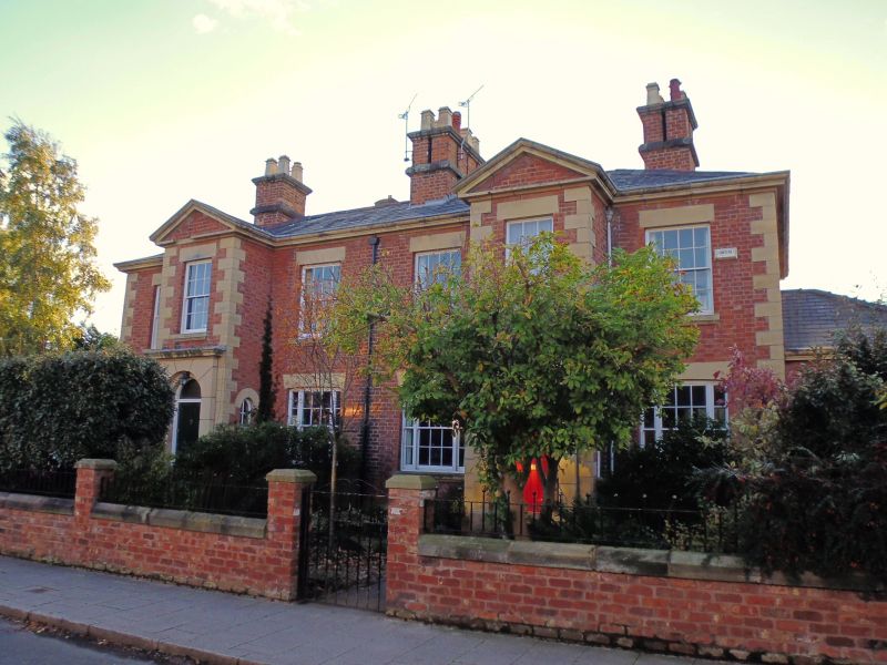
Pair of suburban houses. c1850. Flemish bond brown brick with
stone dressings and hipped grey slate roof.
2 storeys, double-fronted; plinth; flush quoins to corners.
Each house has a projecting 2-storey central porch of yellow
sandstone with a simple round-arched projecting doorcase,
corniced, doors of 4 panels, those to No.41 fielded. Repaired
cross-windows with moulded stone sills and wedge lintels,
those to ground floor with gently cambered soffits; one window
to each side of porch in both storeys and one above each
doorway; stone pediments to porches. Plinthed chimneys, that
to centre with four pairs of divided flues; that to each end
with two pairs of flues. The flank wall of each house has a
square hip-roofed projecting bay.
Rears and INTERIORS not inspected.
HISTORICAL NOTE: the prospective plan, 1847 by C Rampling of
Liverpool for development of this land with detached and
semi-detached villas in substantial gardens was increased in
density, but this item and Nos 15 & 17, 19 & 21, 23 & 25 and
27 & 29 (qv) Hamilton Street reflect the styles proposed in
Rampling's birdseye sketches.
(Rampling C: Plan for development of land off Hoole Road,
Hoole: 1847-).
Listing NGR: SJ 41728 67213
External links are from the relevant listing authority and, where applicable, Wikidata. Wikidata IDs may be related buildings as well as this specific building. If you want to add or update a link, you will need to do so by editing the Wikidata entry.


Other nearby listed buildings
