Approximate Location Map
Large Map »
Latitude: 53.185 / 53°11'5"N
Longitude: -2.8824 / 2°52'56"W
OS Eastings: 341131
OS Northings: 365685
OS Grid: SJ411656
Mapcode National: GBR 7B.38BS
Mapcode Global: WH88F.P6MN
Plus Code: 9C5V54M9+X2
Entry Name: 11 and 13, Victoria Pathway
Listing Date: 21 July 1995
Grade: II
Source: Historic England
Source ID: 1375984
English Heritage Legacy ID: 469965
ID on this website: 101375984
Location: Handbridge, Cheshire West and Chester, Cheshire, CH4
County: Cheshire West and Chester
Electoral Ward/Division: Handbridge Park
Parish: Non Civil Parish
Built-Up Area: Chester
Traditional County: Cheshire
Lieutenancy Area (Ceremonial County): Cheshire
Church of England Parish: Chester St Mary without the Walls
Church of England Diocese: Chester
Tagged with: Building
SJ4165
1932-1/8/296
21/07/95
CHESTER CITY (EM)
VICTORIA PATHWAY
(East side)
Nos.11 AND 13
II
GV
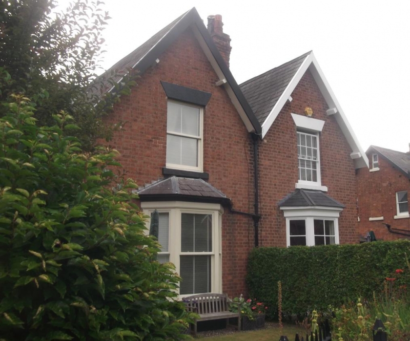
Pair of cottages. c1855. Probably by James Harrison. Flemish
bond brown brick with grey slate roof.
2 storeys with a pair of front-gabled bays flanked by porch
bays. Plinth; step to door of 4 fielded panels with lean-to
porch on brackets; canted bay window to each cottage, glazing
bars removed from No.11, sashes of 4, 8 and 4 panes to No.13;
door of 4 fielded panels with blocked fanlight. A first-floor
sash in main bay of each cottage, bars removed in No.11, of 16
panes in No.13. Bargeboards; 2 plinthed chimneys on party
wall. The left side of No.11 has 2 sashes to ground floor and
3 to first floor of the left end, all glazing bars removed;
the right side of No.13 has 12-pane sashes.
INTERIORS not inspected.
With Nos 2-18, 3-9 and 15 and 17 Victoria Pathway (qv), this
item comprises an unusual example of mid C19 suburban planning
analogous to mid C20 Radburn layouts with a footpath serving
the fronts of the cottages and vehicular streets to their
rear.
Listing NGR: SJ 41131 65685
External links are from the relevant listing authority and, where applicable, Wikidata. Wikidata IDs may be related buildings as well as this specific building. If you want to add or update a link, you will need to do so by editing the Wikidata entry.


Other nearby listed buildings
