Approximate Location Map
Large Map »
Latitude: 53.5005 / 53°30'1"N
Longitude: -1.4782 / 1°28'41"W
OS Eastings: 434710
OS Northings: 400545
OS Grid: SE347005
Mapcode National: GBR LW3Y.SX
Mapcode Global: WHDD3.88BT
Plus Code: 9C5WGG2C+5P
Entry Name: Tankersley Mine Rescue Station
Listing Date: 5 August 1998
Grade: II
Source: Historic England
Source ID: 1376008
English Heritage Legacy ID: 469990
ID on this website: 101376008
Location: Tankersley, Barnsley, South Yorkshire, S70
County: Barnsley
Civil Parish: Tankersley
Built-Up Area: Birdwell
Traditional County: Yorkshire
Lieutenancy Area (Ceremonial County): South Yorkshire
Church of England Parish: Tankersley St Peter
Church of England Diocese: Sheffield
Tagged with: Architectural structure
SE 30 SW
1800/1/10005
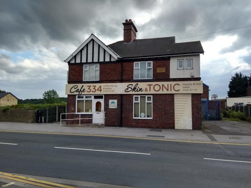
TANKERSLEY
SHEFFIELD ROAD
(East Side)
Tankersley Mine Rescue Station
II
Mines rescue station. 1902 with minor late C20 alterations. Built for the West Yorkshire Coal Mine Owners Association. Red brick with ashlar dressings and slate hipped roof and single brick stack. 2 storey. Street front has doorway to left with panel door, overlight and ashlar lintel. To right 3-light cross casement window and beyond modern casement window replacing former square bay window. Above two 3-light cross casement windows, that to left in half-timbered gable above, to right 2 small casement windows in rendered section, originally half-timbered. To rear courtyard with single and 2 storey outbuildings around 3 sides of the yard, for the storage of mines rescue equipment and transport. This building was the first purpose built Coal Mines Rescue Station to be built in England and it is listed for its important historical associations with the Coal Mining Industry.
Listing NGR: SE3471000545
External links are from the relevant listing authority and, where applicable, Wikidata. Wikidata IDs may be related buildings as well as this specific building. If you want to add or update a link, you will need to do so by editing the Wikidata entry.


Other nearby listed buildings
