Approximate Location Map
Large Map »
Latitude: 53.1927 / 53°11'33"N
Longitude: -2.8989 / 2°53'56"W
OS Eastings: 340038
OS Northings: 366552
OS Grid: SJ400665
Mapcode National: GBR 79.2Y1T
Mapcode Global: WH88F.F0SR
Plus Code: 9C5V54V2+3C
Entry Name: Bonewaldesthorne Tower
Listing Date: 28 July 1955
Last Amended: 6 August 1998
Grade: I
Source: Historic England
Source ID: 1376128
English Heritage Legacy ID: 470118
ID on this website: 101376128
Location: Water Tower Gardens, Chester, Cheshire West and Chester, Cheshire, CH1
County: Cheshire West and Chester
Electoral Ward/Division: Garden Quarter
Parish: Non Civil Parish
Built-Up Area: Chester
Traditional County: Cheshire
Lieutenancy Area (Ceremonial County): Cheshire
Church of England Parish: Chester St Oswald and St Thomas of Canterbury
Church of England Diocese: Chester
Tagged with: Tower
CHESTER CITY (IM)
SJ4066NE CITY WALLS
595-1/1/100 Bonewaldesthorne tower
28/07/55
(Formerly Listed as:
City Walls & Towers incl.
foundations of SE angle Roman
Fortress wall & tower)
GV I
INTRODUCTION
The following items numbered 100 to 132 incorporate elements
of the walls and towers of the Roman fortress of Deva, the
rebuilding and extension to enclose a larger area with walls
and towers by Norman Earls of Chester late C11 and early C12;
later medieval improvements; some C17 alterations; damage
during the Civil War 1644-6; conversion to a raised promenade
1701-8; alteration and stripping of fortified gateways and
most other defensive features C18 and early C19 and breaching
with enlarged or additional archways C20. Roman masonry is of
purple-grey Bunter sandstone, medieval and later masonry of
softer red sandstone.
The earliest defences were Flavian, late C1, of which parts of
the base of the earth rampart survive beneath the stone walls.
Roman masonry of the outer face of the north and east walls
and the foundation of the south-east tower of the legionary
fortress are probably Hadrianic, early C2 but probably altered
and repaired up to C4.
The medieval walls incorporate masonry of the north and east
faces of the Roman walls, but are in part set back from the
face and built upon the Roman turf rampart. They were extended
late C11 and early C12 by the Norman Earls of Chester west and
southward to their present position, possibly on a line set
out by Aethelfled in 907 when she had refortified the burh.
The walls were strengthened 1160-61. Of the surviving medieval
towers Bonewaldesthorne's Tower is probably 1249, the Water
Tower, commanding the site of the medieval port is 1322-6 and
Thimbleby's Tower is undated.
The wall and its towers are described clockwise from
Bonewaldesthorne Tower at the north-west corner, each item
assessed separately for grading. The gates are described under
the streets which they bridge.
The circuit of the City Walls is nearly 2 miles, and the wall
walk approximately at its medieval level except where lowered
and realigned between Bridgegate and Grosvenor Road.
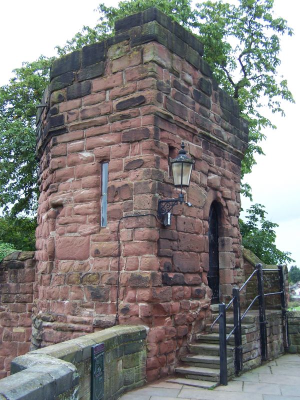
BONEWALDESTHORNE TOWER
EXTERIOR: wall tower. Documented since 1249-61 but rebuilt or
altered 1322-6 after which it formed the gatehouse to the
Water Tower (qv). Red sandstone coursed rubble, eroded. Tall
plinth, with 3 weathered caps to north and one to south, a
blank storey now filled, a storey 7 stone steps up from Row
walk, and battlements on eroded string course. Entrance with
chamfered jambs and arch of 2 stones has oak boarded door.
Doorway on opposite side leads to spur to the Water Tower.
INTERIOR: has a fireplace; stair, now closed, to battlements;
loops.
HISTORICAL NOTE: the masonry of the south-west quadrant of the
tower suggests that the tower was originally a drum, but that
in 1322 it was squared off, north, to the line of the spur
wall to the Water Tower and rebuilt to a square plan with a
canted south-west corner above wall-walk level.
(Bartholomew City Guides: Harris B: Chester: Edinburgh: 1979-:
94-95; The Buildings of England: Pevsner N & Hubbard E:
Cheshire: Harmondsworth: 1971-: 155; Cheshire Sites and
Monuments Record: Collens J: Chester City: 3007/2/3).
Listing NGR: SJ4003866552
External links are from the relevant listing authority and, where applicable, Wikidata. Wikidata IDs may be related buildings as well as this specific building. If you want to add or update a link, you will need to do so by editing the Wikidata entry.


Other nearby listed buildings
