Approximate Location Map
Large Map »
Latitude: 53.1863 / 53°11'10"N
Longitude: -2.8954 / 2°53'43"W
OS Eastings: 340263
OS Northings: 365841
OS Grid: SJ402658
Mapcode National: GBR 79.3C5X
Mapcode Global: WH88F.H5GN
Plus Code: 9C5V54P3+GR
Entry Name: Part of City Wall from Grosvenor Road to the Watergate
Listing Date: 28 July 1955
Last Amended: 6 August 1998
Grade: I
Source: Historic England
Source ID: 1376175
English Heritage Legacy ID: 470169
ID on this website: 101376175
Location: Chester, Cheshire West and Chester, Cheshire, CH1
County: Cheshire West and Chester
Electoral Ward/Division: Chester City
Parish: Non Civil Parish
Built-Up Area: Chester
Traditional County: Cheshire
Lieutenancy Area (Ceremonial County): Cheshire
Church of England Parish: Chester St John the Baptist
Church of England Diocese: Chester
Tagged with: City walls
CHESTER CITY (IM)
SJ4065NW CITY WALLS
595-1/5/130 Part of City Wall from Grosvenor
28/07/55 Road to the Watergate
(Formerly Listed as:
City Walls & Towers incl.
foundations of SE angle Roman
Fortress wall & tower)
GV I
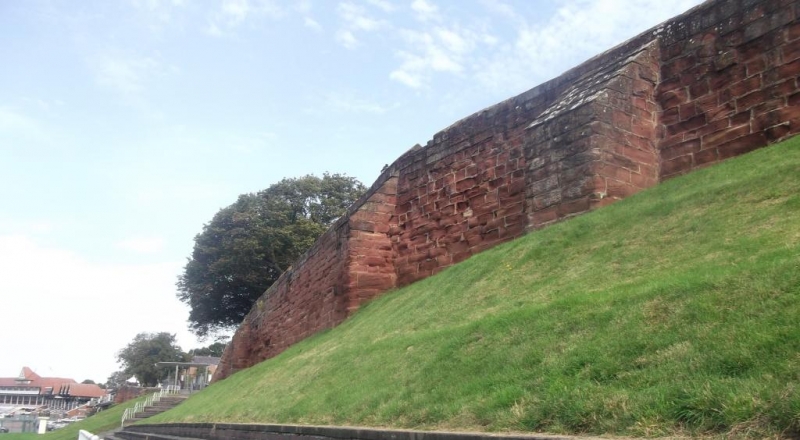
Part of medieval City Walls. Late C11 to early C12 converted
to a promenade 1702-8 and repaired during various periods.
Coursed red sandstone rubble. The outer face, embanked except
in the north part towards the Watergate (qv), displays 8-10
courses above the grass bank and approx 18 courses increasing
to 25 courses, further north. Renewed masonry in the wall face
suggests a possible former turret opposite Black Friars.
Buttresses, probably added.
A C19 projecting turret for stair to racecourse. A double
embrasure, the openings divided by a rib wall, perhaps C17,
immediately south of the Watergate. The masonry suggests
position of south tower of the Watergate.
Much of the pavement occupying the former wall walk is level
with the ground within the wall.
Listing NGR: SJ4026365841
External links are from the relevant listing authority and, where applicable, Wikidata. Wikidata IDs may be related buildings as well as this specific building. If you want to add or update a link, you will need to do so by editing the Wikidata entry.


Other nearby listed buildings
