Approximate Location Map
Large Map »
Latitude: 51.5024 / 51°30'8"N
Longitude: -0.0537 / 0°3'13"W
OS Eastings: 535184
OS Northings: 179963
OS Grid: TQ351799
Mapcode National: GBR JB.33L
Mapcode Global: VHGR1.0HYL
Plus Code: 9C3XGW2W+XG
Entry Name: Thames Tunnel (That Part Which Lies in London Borough of Southwark)
Listing Date: 24 March 1995
Grade: II*
Source: Historic England
Source ID: 1378391
English Heritage Legacy ID: 470692
ID on this website: 101378391
Location: Southwark, London, SE16
County: London
District: Southwark
Electoral Ward/Division: Rotherhithe
Built-Up Area: Southwark
Traditional County: Surrey
Lieutenancy Area (Ceremonial County): Greater London
Church of England Parish: Rotherhithe St Mary with All Saints
Church of England Diocese: Southwark
SOUTHWARK
TQ3579 BRUNEL ROAD
636-1/6/876 Thames Tunnel (that part which lies
24/03/95 in London Borough of Southwark)
II*
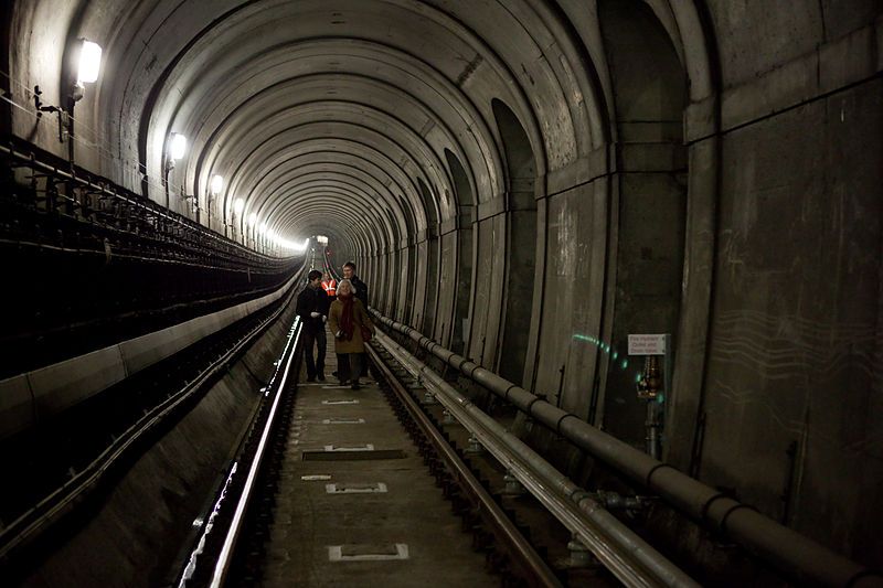
Underwater tunnel for human traffic, now used as a underground
railway tunnel. Begun 1825, completed 1843. By engineer Marc
Isambard Brunel with assistance from Isambard Kingdom Brunel.
Brick bedded in Roman cement and faced with clay tiles and
stucco. Stucco finish in 'ashlar' on top of red clay tile
lining of tunnel.
Approx 366m (1200ft)long. 2 parallel vaults of horseshoe
section, 4.27m (14ft) wide by 4.88m (16ft) high and joined at
intervals by cross arches encased in a rectangular brick
framework 11.58m (38ft) wide and 6.7m (22ft) high externally.
At the end are access shafts 15.24m (50ft) across. Segmental
arches separating the 2 vaults 'rest' on Greek Doric
half-columns with square abaci. Many arches have been filled
in.
HISTORICAL NOTE: experimental attempts to construct a tunnel
were made in 1805 by Robert Vazie and again in 1808 by Richard
Trevithick. The present tunnel was constructed on a new line
to a revised scheme by Marc Brunel (1769-1849) using a
tunnelling shield designed by him and patented in 1818. The
tunnel was opened on 26 May 1843. It remained a foot tunnel
until 1865-1869 when it was converted for the East London
Railway. Later used by electric underground trains (East
London Line).
The northern part of this item is situated in the London
Borough of Tower Hamlets.
Listing NGR: TQ3516479990
This text is from the original listing, and may not necessarily reflect the current setting of the building.
External links are from the relevant listing authority and, where applicable, Wikidata. Wikidata IDs may be related buildings as well as this specific building. If you want to add or update a link, you will need to do so by editing the Wikidata entry.


Other nearby listed buildings
